You are here: Home > Network List > TA - USArray Transportable Network (new EarthScope stations) Stations List
> Station 121A Cookes Peak, Deming, NM, USA > Earthquake Result Viewer
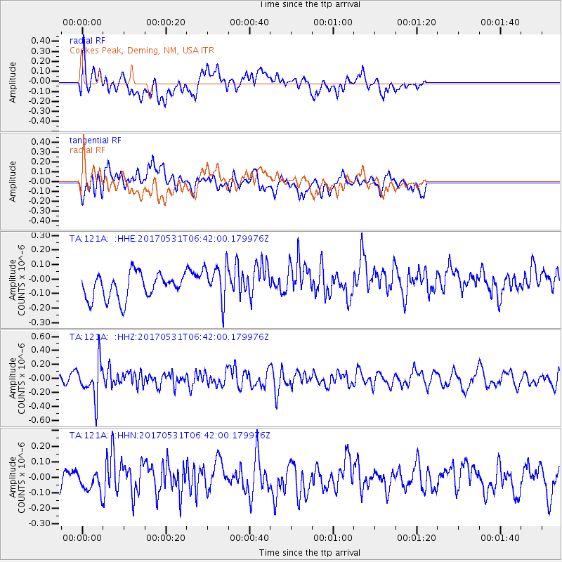
121A Cookes Peak, Deming, NM, USA - Earthquake Result Viewer
*The percent match for this event was below the threshold and hence no stack was calculated.
| Earthquake location: |
Mariana Islands |
| Earthquake latitude/longitude: |
19.1/145.9 |
| Earthquake time(UTC): |
2017/05/31 (151) 06:29:32 GMT |
| Earthquake Depth: |
121 km |
| Earthquake Magnitude: |
5.4 Mww |
| Earthquake Catalog/Contributor: |
NEIC PDE/us |
|
| Network: |
TA USArray Transportable Network (new EarthScope stations) |
| Station: |
121A Cookes Peak, Deming, NM, USA |
| Lat/Lon: |
32.53 N/107.79 W |
| Elevation: |
1652 m |
|
| Distance: |
92.9 deg |
| Az: |
54.25 deg |
| Baz: |
294.696 deg |
| Ray Param: |
$rayparam |
*The percent match for this event was below the threshold and hence was not used in the summary stack. |
|
| Radial Match: |
61.30015 % |
| Radial Bump: |
400 |
| Transverse Match: |
49.49244 % |
| Transverse Bump: |
400 |
| SOD ConfigId: |
13570011 |
| Insert Time: |
2019-04-28 03:00:53.321 +0000 |
| GWidth: |
2.5 |
| Max Bumps: |
400 |
| Tol: |
0.001 |
|
Signal To Noise
| Channel | StoN | STA | LTA |
| TA:121A: :HHZ:20170531T06:42:00.179976Z | 2.9334083 | 2.6083194E-7 | 8.891771E-8 |
| TA:121A: :HHN:20170531T06:42:00.179976Z | 0.7644553 | 6.5908566E-8 | 8.6216374E-8 |
| TA:121A: :HHE:20170531T06:42:00.179976Z | 1.5429188 | 1.3309422E-7 | 8.626132E-8 |
| Arrivals |
| Ps | |
| PpPs | |
| PsPs/PpSs | |


