You are here: Home > Network List > TA - USArray Transportable Network (new EarthScope stations) Stations List
> Station N31M Braeburn, Yukon, CA > Earthquake Result Viewer
N31M Braeburn, Yukon, CA - Earthquake Result Viewer
| Earthquake location: |
Mariana Islands |
| Earthquake latitude/longitude: |
19.1/145.9 |
| Earthquake time(UTC): |
2017/05/31 (151) 06:29:32 GMT |
| Earthquake Depth: |
121 km |
| Earthquake Magnitude: |
5.4 Mww |
| Earthquake Catalog/Contributor: |
NEIC PDE/us |
|
| Network: |
TA USArray Transportable Network (new EarthScope stations) |
| Station: |
N31M Braeburn, Yukon, CA |
| Lat/Lon: |
61.49 N/135.78 W |
| Elevation: |
716 m |
|
| Distance: |
67.9 deg |
| Az: |
30.49 deg |
| Baz: |
269.302 deg |
| Ray Param: |
0.056360975 |
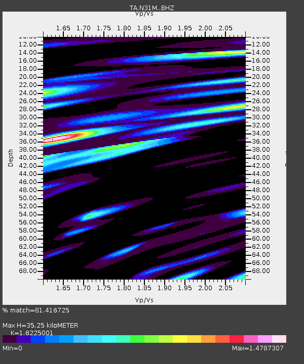
| Estimated Moho Depth: |
35.25 km |
| Estimated Crust Vp/Vs: |
1.62 |
| Assumed Crust Vp: |
6.419 km/s |
| Estimated Crust Vs: |
3.956 km/s |
| Estimated Crust Poisson's Ratio: |
0.19 |
|
| Radial Match: |
81.416725 % |
| Radial Bump: |
400 |
| Transverse Match: |
61.420868 % |
| Transverse Bump: |
400 |
| SOD ConfigId: |
13570011 |
| Insert Time: |
2019-04-28 03:02:01.683 +0000 |
| GWidth: |
2.5 |
| Max Bumps: |
400 |
| Tol: |
0.001 |
|

Signal To Noise
| Channel | StoN | STA | LTA |
| TA:N31M: :BHZ:20170531T06:39:46.574995Z | 7.6636724 | 5.558927E-7 | 7.2536075E-8 |
| TA:N31M: :BHN:20170531T06:39:46.574995Z | 2.1912036 | 1.6606413E-7 | 7.578672E-8 |
| TA:N31M: :BHE:20170531T06:39:46.574995Z | 4.0165462 | 2.6614248E-7 | 6.626153E-8 |
| Arrivals |
| Ps | 3.6 SECOND |
| PpPs | 14 SECOND |
| PsPs/PpSs | 17 SECOND |


