You are here: Home > Network List > TA - USArray Transportable Network (new EarthScope stations) Stations List
> Station TPFO Pinon Flats, CA, USA > Earthquake Result Viewer
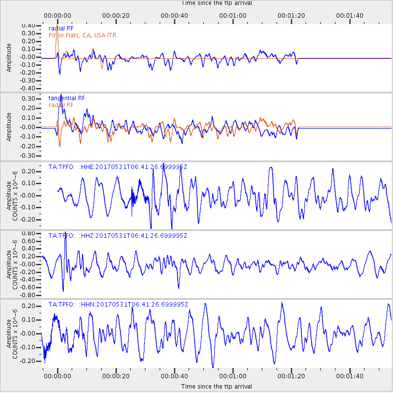
TPFO Pinon Flats, CA, USA - Earthquake Result Viewer
*The percent match for this event was below the threshold and hence no stack was calculated.
| Earthquake location: |
Mariana Islands |
| Earthquake latitude/longitude: |
19.1/145.9 |
| Earthquake time(UTC): |
2017/05/31 (151) 06:29:32 GMT |
| Earthquake Depth: |
121 km |
| Earthquake Magnitude: |
5.4 Mww |
| Earthquake Catalog/Contributor: |
NEIC PDE/us |
|
| Network: |
TA USArray Transportable Network (new EarthScope stations) |
| Station: |
TPFO Pinon Flats, CA, USA |
| Lat/Lon: |
33.61 N/116.45 W |
| Elevation: |
1275 m |
|
| Distance: |
85.8 deg |
| Az: |
56.028 deg |
| Baz: |
290.001 deg |
| Ray Param: |
$rayparam |
*The percent match for this event was below the threshold and hence was not used in the summary stack. |
|
| Radial Match: |
52.00553 % |
| Radial Bump: |
396 |
| Transverse Match: |
78.59985 % |
| Transverse Bump: |
400 |
| SOD ConfigId: |
13570011 |
| Insert Time: |
2019-04-28 03:02:36.982 +0000 |
| GWidth: |
2.5 |
| Max Bumps: |
400 |
| Tol: |
0.001 |
|
Signal To Noise
| Channel | StoN | STA | LTA |
| TA:TPFO: :HHZ:20170531T06:41:26.699995Z | 2.9431908 | 3.3918903E-7 | 1.15245335E-7 |
| TA:TPFO: :HHN:20170531T06:41:26.699995Z | 1.0764734 | 8.3411976E-8 | 7.748634E-8 |
| TA:TPFO: :HHE:20170531T06:41:26.699995Z | 1.2967364 | 1.14710616E-7 | 8.8461015E-8 |
| Arrivals |
| Ps | |
| PpPs | |
| PsPs/PpSs | |


