You are here: Home > Network List > UW - Pacific Northwest Regional Seismic Network Stations List
> Station MRBL Marblemount, WA, USA > Earthquake Result Viewer
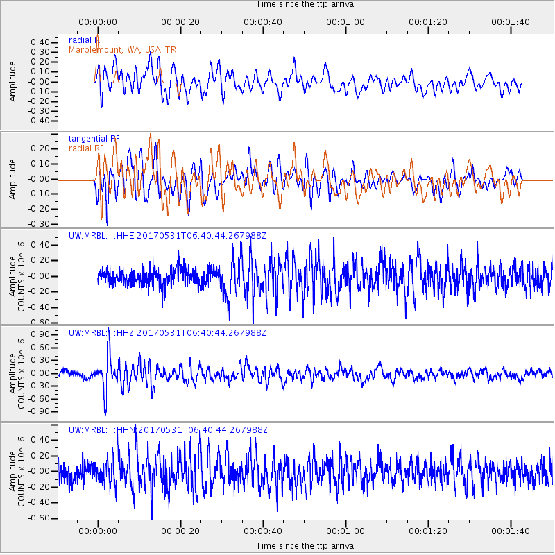
MRBL Marblemount, WA, USA - Earthquake Result Viewer
*The percent match for this event was below the threshold and hence no stack was calculated.
| Earthquake location: |
Mariana Islands |
| Earthquake latitude/longitude: |
19.1/145.9 |
| Earthquake time(UTC): |
2017/05/31 (151) 06:29:32 GMT |
| Earthquake Depth: |
121 km |
| Earthquake Magnitude: |
5.4 Mww |
| Earthquake Catalog/Contributor: |
NEIC PDE/us |
|
| Network: |
UW Pacific Northwest Regional Seismic Network |
| Station: |
MRBL Marblemount, WA, USA |
| Lat/Lon: |
48.52 N/121.48 W |
| Elevation: |
75 m |
|
| Distance: |
77.7 deg |
| Az: |
42.833 deg |
| Baz: |
284.767 deg |
| Ray Param: |
$rayparam |
*The percent match for this event was below the threshold and hence was not used in the summary stack. |
|
| Radial Match: |
74.37879 % |
| Radial Bump: |
400 |
| Transverse Match: |
74.87129 % |
| Transverse Bump: |
400 |
| SOD ConfigId: |
13570011 |
| Insert Time: |
2019-04-28 03:03:39.402 +0000 |
| GWidth: |
2.5 |
| Max Bumps: |
400 |
| Tol: |
0.001 |
|
Signal To Noise
| Channel | StoN | STA | LTA |
| UW:MRBL: :HHZ:20170531T06:40:44.267988Z | 5.324365 | 4.2170103E-7 | 7.920213E-8 |
| UW:MRBL: :HHN:20170531T06:40:44.267988Z | 2.09355 | 1.6855026E-7 | 8.05093E-8 |
| UW:MRBL: :HHE:20170531T06:40:44.267988Z | 2.4778423 | 2.399148E-7 | 9.682409E-8 |
| Arrivals |
| Ps | |
| PpPs | |
| PsPs/PpSs | |


