You are here: Home > Network List > UW - Pacific Northwest Regional Seismic Network Stations List
> Station UMAT Pilot Rock, OR, USA > Earthquake Result Viewer
UMAT Pilot Rock, OR, USA - Earthquake Result Viewer
*The percent match for this event was below the threshold and hence no stack was calculated.
| Earthquake location: |
Mariana Islands |
| Earthquake latitude/longitude: |
19.1/145.9 |
| Earthquake time(UTC): |
2017/05/31 (151) 06:29:32 GMT |
| Earthquake Depth: |
121 km |
| Earthquake Magnitude: |
5.4 Mww |
| Earthquake Catalog/Contributor: |
NEIC PDE/us |
|
| Network: |
UW Pacific Northwest Regional Seismic Network |
| Station: |
UMAT Pilot Rock, OR, USA |
| Lat/Lon: |
45.29 N/118.96 W |
| Elevation: |
1318 m |
|
| Distance: |
80.2 deg |
| Az: |
45.512 deg |
| Baz: |
287.12 deg |
| Ray Param: |
$rayparam |
*The percent match for this event was below the threshold and hence was not used in the summary stack. |
|
| Radial Match: |
66.083145 % |
| Radial Bump: |
400 |
| Transverse Match: |
73.81445 % |
| Transverse Bump: |
400 |
| SOD ConfigId: |
13570011 |
| Insert Time: |
2019-04-28 03:03:45.373 +0000 |
| GWidth: |
2.5 |
| Max Bumps: |
400 |
| Tol: |
0.001 |
|
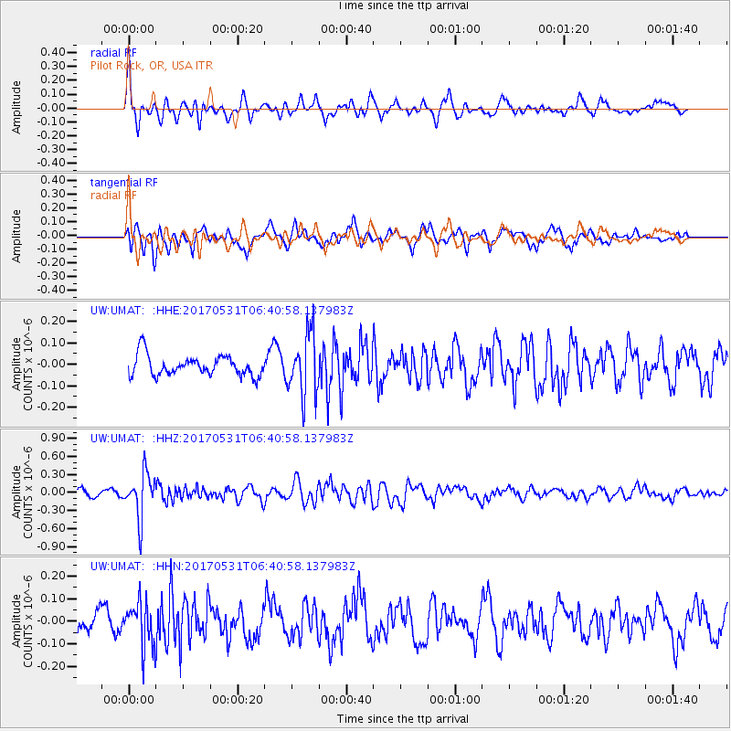
Signal To Noise
| Channel | StoN | STA | LTA |
| UW:UMAT: :HHZ:20170531T06:40:58.137983Z | 6.1020722 | 3.7691922E-7 | 6.176905E-8 |
| UW:UMAT: :HHN:20170531T06:40:58.137983Z | 2.8914013 | 9.789042E-8 | 3.3855702E-8 |
| UW:UMAT: :HHE:20170531T06:40:58.137983Z | 3.1002445 | 1.4733847E-7 | 4.752479E-8 |
| Arrivals |
| Ps | |
| PpPs | |
| PsPs/PpSs | |


