You are here: Home > Network List > 5H - Central Virginia and South Carolina seismic monitoring experiment Stations List
> Station DAVE Dillwyn, VA > Earthquake Result Viewer
DAVE Dillwyn, VA - Earthquake Result Viewer
| Earthquake location: |
Near Islands, Aleutian Islands |
| Earthquake latitude/longitude: |
54.0/170.9 |
| Earthquake time(UTC): |
2017/06/02 (153) 22:24:47 GMT |
| Earthquake Depth: |
8.2 km |
| Earthquake Magnitude: |
6.8 Mww |
| Earthquake Catalog/Contributor: |
NEIC PDE/us |
|
| Network: |
5H Central Virginia and South Carolina seismic monitoring experiment |
| Station: |
DAVE Dillwyn, VA |
| Lat/Lon: |
37.55 N/78.37 W |
| Elevation: |
130 m |
|
| Distance: |
71.1 deg |
| Az: |
51.795 deg |
| Baz: |
324.318 deg |
| Ray Param: |
0.054556303 |
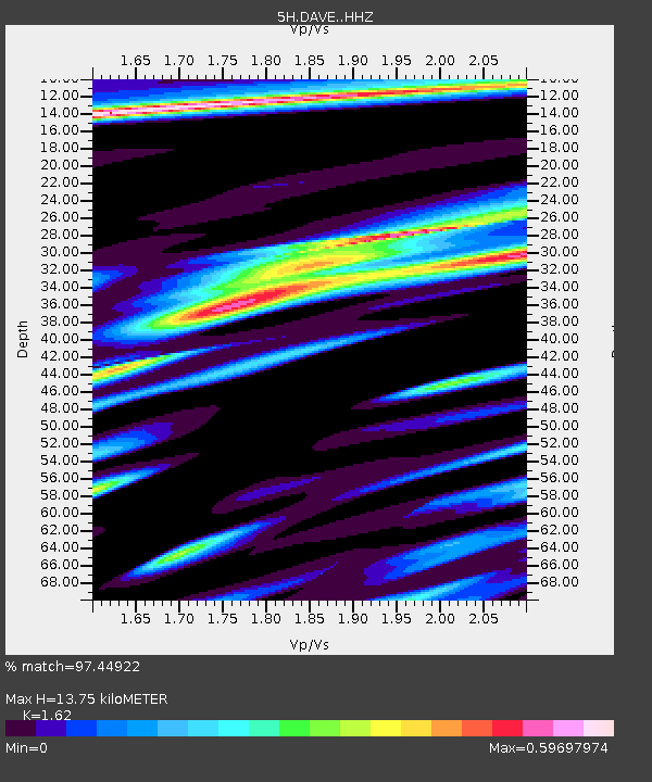
| Estimated Moho Depth: |
13.75 km |
| Estimated Crust Vp/Vs: |
1.62 |
| Assumed Crust Vp: |
6.419 km/s |
| Estimated Crust Vs: |
3.962 km/s |
| Estimated Crust Poisson's Ratio: |
0.19 |
|
| Radial Match: |
97.44922 % |
| Radial Bump: |
400 |
| Transverse Match: |
85.77131 % |
| Transverse Bump: |
400 |
| SOD ConfigId: |
13570011 |
| Insert Time: |
2019-04-28 03:04:36.314 +0000 |
| GWidth: |
2.5 |
| Max Bumps: |
400 |
| Tol: |
0.001 |
|

Signal To Noise
| Channel | StoN | STA | LTA |
| 5H:DAVE: :HHZ:20170602T22:35:35.264971Z | 30.33594 | 1.5595798E-6 | 5.14103E-8 |
| 5H:DAVE: :HHN:20170602T22:35:35.264971Z | 7.11563 | 4.8607984E-7 | 6.8311564E-8 |
| 5H:DAVE: :HHE:20170602T22:35:35.264971Z | 6.607019 | 3.1374717E-7 | 4.7486946E-8 |
| Arrivals |
| Ps | 1.4 SECOND |
| PpPs | 5.4 SECOND |
| PsPs/PpSs | 6.8 SECOND |


