You are here: Home > Network List > CA - Catalan Seismic Network Stations List
> Station CFAR Far de la Banya > Earthquake Result Viewer
CFAR Far de la Banya - Earthquake Result Viewer
| Earthquake location: |
Near Islands, Aleutian Islands |
| Earthquake latitude/longitude: |
54.0/170.9 |
| Earthquake time(UTC): |
2017/06/02 (153) 22:24:47 GMT |
| Earthquake Depth: |
8.2 km |
| Earthquake Magnitude: |
6.8 Mww |
| Earthquake Catalog/Contributor: |
NEIC PDE/us |
|
| Network: |
CA Catalan Seismic Network |
| Station: |
CFAR Far de la Banya |
| Lat/Lon: |
40.56 N/0.66 E |
| Elevation: |
2.0 m |
|
| Distance: |
85.4 deg |
| Az: |
352.562 deg |
| Baz: |
5.753 deg |
| Ray Param: |
0.044787183 |
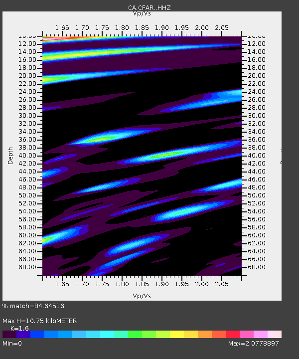
| Estimated Moho Depth: |
10.75 km |
| Estimated Crust Vp/Vs: |
1.60 |
| Assumed Crust Vp: |
6.391 km/s |
| Estimated Crust Vs: |
3.994 km/s |
| Estimated Crust Poisson's Ratio: |
0.18 |
|
| Radial Match: |
84.64516 % |
| Radial Bump: |
400 |
| Transverse Match: |
80.94151 % |
| Transverse Bump: |
400 |
| SOD ConfigId: |
13570011 |
| Insert Time: |
2019-04-28 03:05:32.728 +0000 |
| GWidth: |
2.5 |
| Max Bumps: |
400 |
| Tol: |
0.001 |
|

Signal To Noise
| Channel | StoN | STA | LTA |
| CA:CFAR: :HHZ:20170602T22:36:54.260027Z | 2.1252296 | 1.9686538E-6 | 9.2632524E-7 |
| CA:CFAR: :HHN:20170602T22:36:54.260027Z | 1.343917 | 1.2667917E-6 | 9.4261156E-7 |
| CA:CFAR: :HHE:20170602T22:36:54.260027Z | 0.87632227 | 9.838304E-7 | 1.1226812E-6 |
| Arrivals |
| Ps | 1.0 SECOND |
| PpPs | 4.3 SECOND |
| PsPs/PpSs | 5.3 SECOND |


