You are here: Home > Network List > CA - Catalan Seismic Network Stations List
> Station EBR Ebre > Earthquake Result Viewer
EBR Ebre - Earthquake Result Viewer

| Earthquake location: |
Near Islands, Aleutian Islands |
| Earthquake latitude/longitude: |
54.0/170.9 |
| Earthquake time(UTC): |
2017/06/02 (153) 22:24:47 GMT |
| Earthquake Depth: |
8.2 km |
| Earthquake Magnitude: |
6.8 Mww |
| Earthquake Catalog/Contributor: |
NEIC PDE/us |
|
| Network: |
CA Catalan Seismic Network |
| Station: |
EBR Ebre |
| Lat/Lon: |
40.82 N/0.49 E |
| Elevation: |
36 m |
|
| Distance: |
85.2 deg |
| Az: |
352.715 deg |
| Baz: |
5.657 deg |
| Ray Param: |
0.044963744 |
| Estimated Moho Depth: |
64.5 km |
| Estimated Crust Vp/Vs: |
2.04 |
| Assumed Crust Vp: |
6.391 km/s |
| Estimated Crust Vs: |
3.14 km/s |
| Estimated Crust Poisson's Ratio: |
0.34 |
|
| Radial Match: |
89.448746 % |
| Radial Bump: |
400 |
| Transverse Match: |
78.781944 % |
| Transverse Bump: |
400 |
| SOD ConfigId: |
13570011 |
| Insert Time: |
2019-04-28 03:05:38.313 +0000 |
| GWidth: |
2.5 |
| Max Bumps: |
400 |
| Tol: |
0.001 |
|
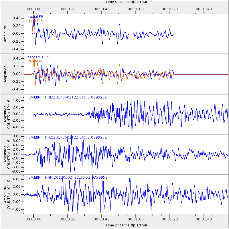
Signal To Noise
| Channel | StoN | STA | LTA |
| CA:EBR: :HHZ:20170602T22:36:53.039995Z | 7.9118094 | 1.5531494E-6 | 1.9630774E-7 |
| CA:EBR: :HHN:20170602T22:36:53.039995Z | 2.7856698 | 5.470323E-7 | 1.9637369E-7 |
| CA:EBR: :HHE:20170602T22:36:53.039995Z | 2.1223993 | 3.8654855E-7 | 1.8212809E-7 |
| Arrivals |
| Ps | 11 SECOND |
| PpPs | 30 SECOND |
| PsPs/PpSs | 41 SECOND |


