You are here: Home > Network List > CB - China National Seismic Network Stations List
> Station HHC Huhehaote,Neimeng Province > Earthquake Result Viewer
HHC Huhehaote,Neimeng Province - Earthquake Result Viewer
| Earthquake location: |
Near Islands, Aleutian Islands |
| Earthquake latitude/longitude: |
54.0/170.9 |
| Earthquake time(UTC): |
2017/06/02 (153) 22:24:47 GMT |
| Earthquake Depth: |
8.2 km |
| Earthquake Magnitude: |
6.8 Mww |
| Earthquake Catalog/Contributor: |
NEIC PDE/us |
|
| Network: |
CB China National Seismic Network |
| Station: |
HHC Huhehaote,Neimeng Province |
| Lat/Lon: |
40.85 N/111.56 E |
| Elevation: |
1169 m |
|
| Distance: |
41.0 deg |
| Az: |
276.305 deg |
| Baz: |
50.624 deg |
| Ray Param: |
0.07404674 |
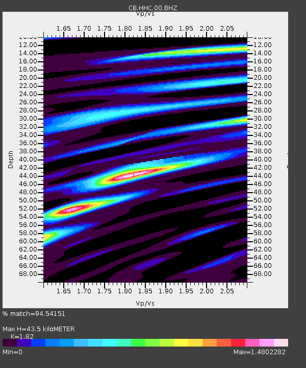
| Estimated Moho Depth: |
43.5 km |
| Estimated Crust Vp/Vs: |
1.82 |
| Assumed Crust Vp: |
6.384 km/s |
| Estimated Crust Vs: |
3.508 km/s |
| Estimated Crust Poisson's Ratio: |
0.28 |
|
| Radial Match: |
94.54151 % |
| Radial Bump: |
372 |
| Transverse Match: |
82.65301 % |
| Transverse Bump: |
400 |
| SOD ConfigId: |
13570011 |
| Insert Time: |
2019-04-28 03:05:43.934 +0000 |
| GWidth: |
2.5 |
| Max Bumps: |
400 |
| Tol: |
0.001 |
|

Signal To Noise
| Channel | StoN | STA | LTA |
| CB:HHC:00:BHZ:20170602T22:32:00.729998Z | 16.173971 | 2.0542886E-6 | 1.2701202E-7 |
| CB:HHC:00:BHN:20170602T22:32:00.729998Z | 4.8610272 | 7.479953E-7 | 1.5387596E-7 |
| CB:HHC:00:BHE:20170602T22:32:00.729998Z | 6.4954042 | 1.0554322E-6 | 1.6248907E-7 |
| Arrivals |
| Ps | 6.0 SECOND |
| PpPs | 18 SECOND |
| PsPs/PpSs | 24 SECOND |


