You are here: Home > Network List > NE - New England Seismic Network Stations List
> Station HNH Hanover, NH, USA > Earthquake Result Viewer
HNH Hanover, NH, USA - Earthquake Result Viewer
| Earthquake location: |
Near Coast Of Chiapas, Mexico |
| Earthquake latitude/longitude: |
15.9/-93.4 |
| Earthquake time(UTC): |
2015/12/17 (351) 19:49:54 GMT |
| Earthquake Depth: |
97 km |
| Earthquake Magnitude: |
6.4 MWB, 6.6 MI |
| Earthquake Catalog/Contributor: |
NEIC PDE/NEIC COMCAT |
|
| Network: |
NE New England Seismic Network |
| Station: |
HNH Hanover, NH, USA |
| Lat/Lon: |
43.71 N/72.29 W |
| Elevation: |
180 m |
|
| Distance: |
33.0 deg |
| Az: |
28.666 deg |
| Baz: |
219.531 deg |
| Ray Param: |
0.07811721 |
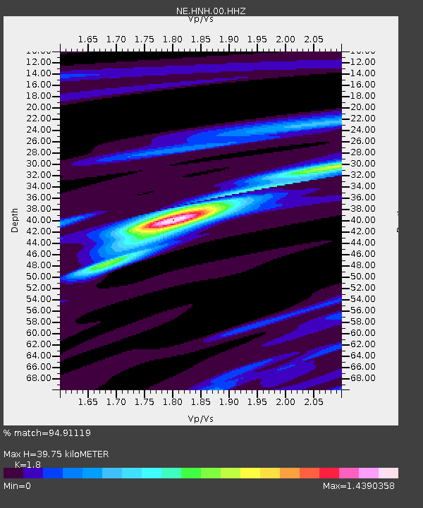
| Estimated Moho Depth: |
39.75 km |
| Estimated Crust Vp/Vs: |
1.80 |
| Assumed Crust Vp: |
6.419 km/s |
| Estimated Crust Vs: |
3.566 km/s |
| Estimated Crust Poisson's Ratio: |
0.28 |
|
| Radial Match: |
94.91119 % |
| Radial Bump: |
148 |
| Transverse Match: |
87.4825 % |
| Transverse Bump: |
360 |
| SOD ConfigId: |
1259291 |
| Insert Time: |
2015-12-31 20:19:56.095 +0000 |
| GWidth: |
2.5 |
| Max Bumps: |
400 |
| Tol: |
0.001 |
|

Signal To Noise
| Channel | StoN | STA | LTA |
| NE:HNH:00:HHZ:20151217T19:55:50.82399Z | 9.088506 | 2.946224E-6 | 3.2417034E-7 |
| NE:HNH:00:HH1:20151217T19:55:50.82399Z | 7.639311 | 2.07114E-6 | 2.7111608E-7 |
| NE:HNH:00:HH2:20151217T19:55:50.82399Z | 2.318264 | 6.034963E-7 | 2.603225E-7 |
| Arrivals |
| Ps | 5.3 SECOND |
| PpPs | 16 SECOND |
| PsPs/PpSs | 21 SECOND |


