You are here: Home > Network List > TA - USArray Transportable Network (new EarthScope stations) Stations List
> Station X31A McDonald Ranch, Hollis, OK, USA > Earthquake Result Viewer
X31A McDonald Ranch, Hollis, OK, USA - Earthquake Result Viewer

| Earthquake location: |
Kuril Islands |
| Earthquake latitude/longitude: |
50.8/155.0 |
| Earthquake time(UTC): |
2009/04/21 (111) 05:26:11 GMT |
| Earthquake Depth: |
152 km |
| Earthquake Magnitude: |
6.0 MB, 6.2 MW, 6.2 MW |
| Earthquake Catalog/Contributor: |
WHDF/NEIC |
|
| Network: |
TA USArray Transportable Network (new EarthScope stations) |
| Station: |
X31A McDonald Ranch, Hollis, OK, USA |
| Lat/Lon: |
34.63 N/99.98 W |
| Elevation: |
514 m |
|
| Distance: |
72.4 deg |
| Az: |
56.665 deg |
| Baz: |
320.023 deg |
| Ray Param: |
0.053278297 |
| Estimated Moho Depth: |
44.25 km |
| Estimated Crust Vp/Vs: |
1.63 |
| Assumed Crust Vp: |
6.315 km/s |
| Estimated Crust Vs: |
3.874 km/s |
| Estimated Crust Poisson's Ratio: |
0.20 |
|
| Radial Match: |
82.299644 % |
| Radial Bump: |
400 |
| Transverse Match: |
73.76619 % |
| Transverse Bump: |
400 |
| SOD ConfigId: |
2760 |
| Insert Time: |
2010-03-06 00:18:11.978 +0000 |
| GWidth: |
2.5 |
| Max Bumps: |
400 |
| Tol: |
0.001 |
|
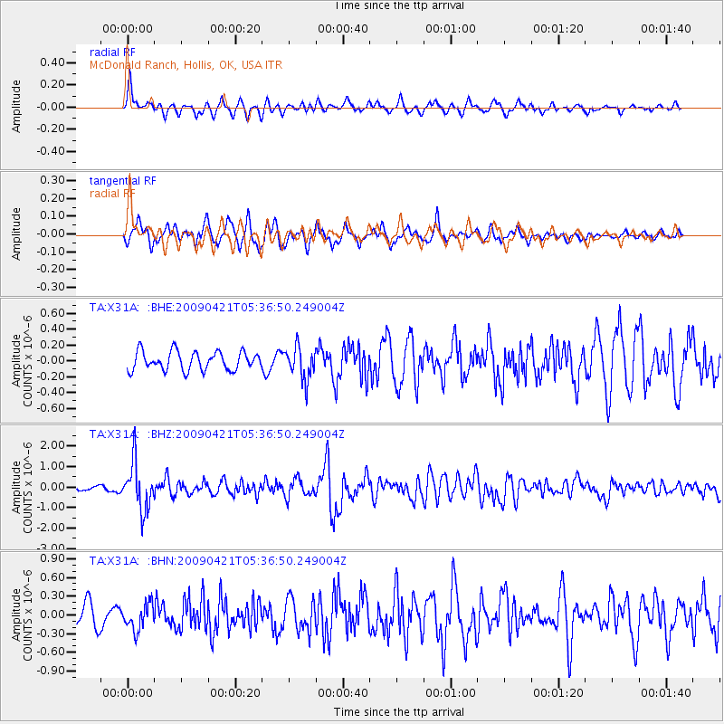
Signal To Noise
| Channel | StoN | STA | LTA |
| TA:X31A: :BHZ:20090421T05:36:50.249004Z | 13.273647 | 1.151137E-6 | 8.672349E-8 |
| TA:X31A: :BHN:20090421T05:36:50.249004Z | 1.3929198 | 2.0416064E-7 | 1.4657027E-7 |
| TA:X31A: :BHE:20090421T05:36:50.249004Z | 1.7278631 | 2.022237E-7 | 1.17036876E-7 |
| Arrivals |
| Ps | 4.6 SECOND |
| PpPs | 18 SECOND |
| PsPs/PpSs | 22 SECOND |


