You are here: Home > Network List > TA - USArray Transportable Network (new EarthScope stations) Stations List
> Station X31A McDonald Ranch, Hollis, OK, USA > Earthquake Result Viewer
X31A McDonald Ranch, Hollis, OK, USA - Earthquake Result Viewer

| Earthquake location: |
Southeast Of Honshu, Japan |
| Earthquake latitude/longitude: |
32.8/140.4 |
| Earthquake time(UTC): |
2009/08/12 (224) 22:48:51 GMT |
| Earthquake Depth: |
53 km |
| Earthquake Magnitude: |
6.2 MB, 6.6 MW, 6.6 MW |
| Earthquake Catalog/Contributor: |
WHDF/NEIC |
|
| Network: |
TA USArray Transportable Network (new EarthScope stations) |
| Station: |
X31A McDonald Ranch, Hollis, OK, USA |
| Lat/Lon: |
34.63 N/99.98 W |
| Elevation: |
514 m |
|
| Distance: |
92.2 deg |
| Az: |
45.835 deg |
| Baz: |
312.906 deg |
| Ray Param: |
0.041479055 |
| Estimated Moho Depth: |
31.5 km |
| Estimated Crust Vp/Vs: |
1.82 |
| Assumed Crust Vp: |
6.315 km/s |
| Estimated Crust Vs: |
3.47 km/s |
| Estimated Crust Poisson's Ratio: |
0.28 |
|
| Radial Match: |
88.77822 % |
| Radial Bump: |
400 |
| Transverse Match: |
80.31272 % |
| Transverse Bump: |
400 |
| SOD ConfigId: |
2622 |
| Insert Time: |
2010-03-06 00:18:17.997 +0000 |
| GWidth: |
2.5 |
| Max Bumps: |
400 |
| Tol: |
0.001 |
|
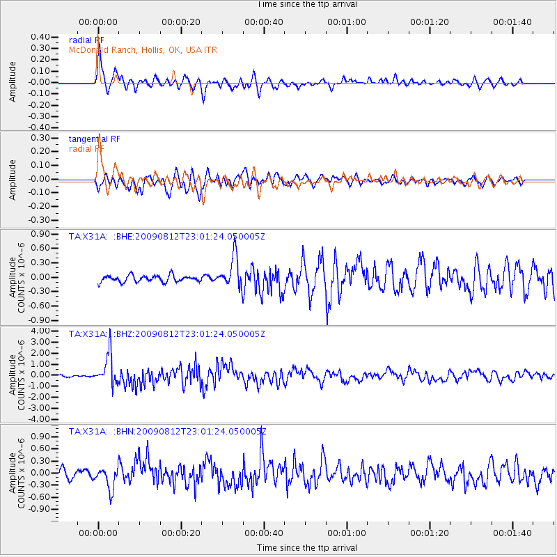
Signal To Noise
| Channel | StoN | STA | LTA |
| TA:X31A: :BHZ:20090812T23:01:24.050005Z | 25.72946 | 1.426432E-6 | 5.5439646E-8 |
| TA:X31A: :BHN:20090812T23:01:24.050005Z | 3.0017073 | 2.7092162E-7 | 9.0255845E-8 |
| TA:X31A: :BHE:20090812T23:01:24.050005Z | 4.9300675 | 3.3627975E-7 | 6.820997E-8 |
| Arrivals |
| Ps | 4.2 SECOND |
| PpPs | 14 SECOND |
| PsPs/PpSs | 18 SECOND |


