You are here: Home > Network List > CI - Caltech Regional Seismic Network Stations List
> Station NEE2 Needles Airport > Earthquake Result Viewer
NEE2 Needles Airport - Earthquake Result Viewer
| Earthquake location: |
Near Islands, Aleutian Islands |
| Earthquake latitude/longitude: |
54.0/170.9 |
| Earthquake time(UTC): |
2017/06/02 (153) 22:24:47 GMT |
| Earthquake Depth: |
8.2 km |
| Earthquake Magnitude: |
6.8 Mww |
| Earthquake Catalog/Contributor: |
NEIC PDE/us |
|
| Network: |
CI Caltech Regional Seismic Network |
| Station: |
NEE2 Needles Airport |
| Lat/Lon: |
34.77 N/114.62 W |
| Elevation: |
271 m |
|
| Distance: |
54.0 deg |
| Az: |
78.808 deg |
| Baz: |
315.333 deg |
| Ray Param: |
0.06575586 |
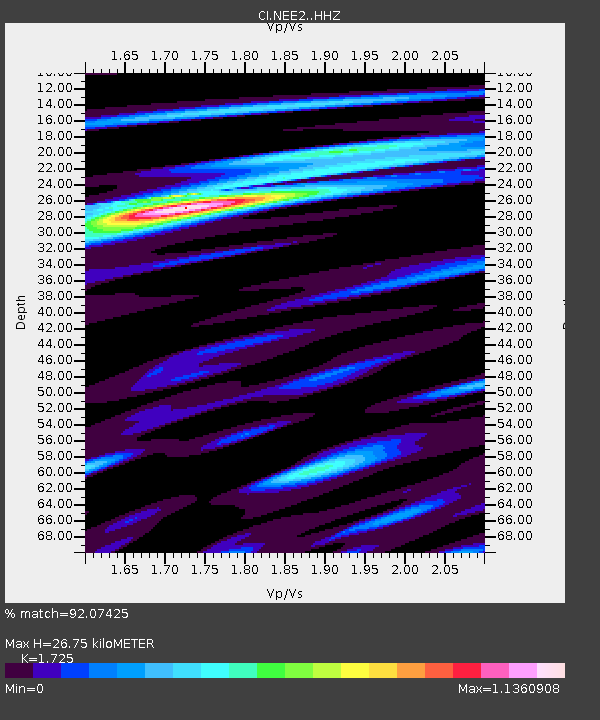
| Estimated Moho Depth: |
26.75 km |
| Estimated Crust Vp/Vs: |
1.73 |
| Assumed Crust Vp: |
6.276 km/s |
| Estimated Crust Vs: |
3.638 km/s |
| Estimated Crust Poisson's Ratio: |
0.25 |
|
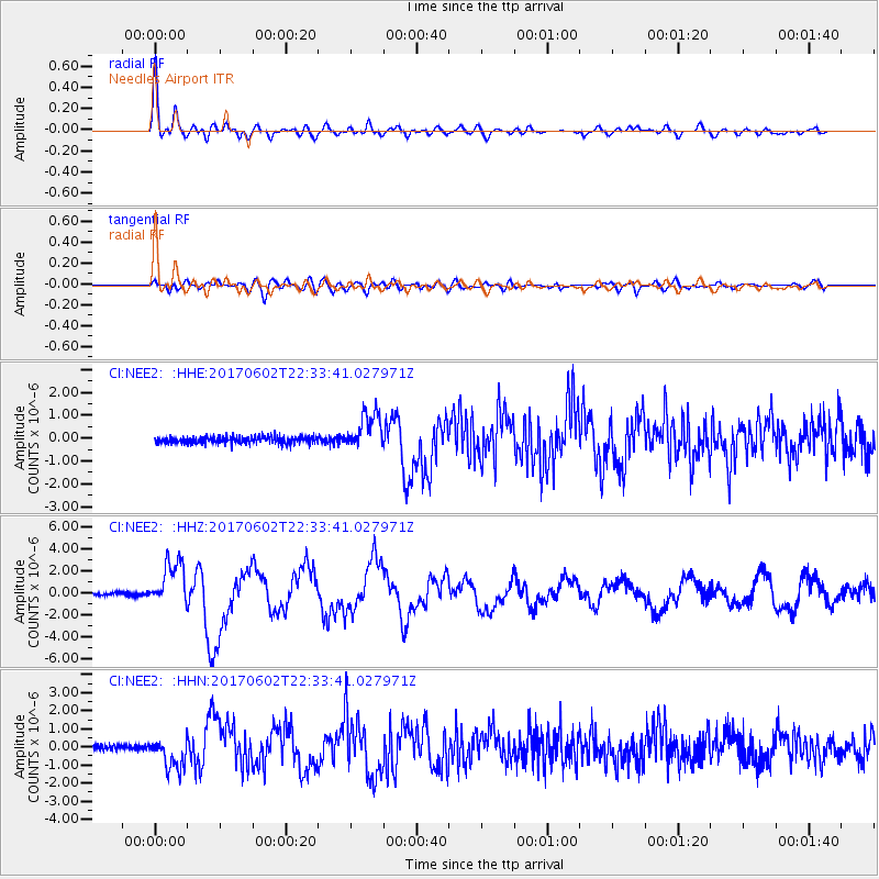
| Radial Match: |
92.07425 % |
| Radial Bump: |
400 |
| Transverse Match: |
77.83859 % |
| Transverse Bump: |
400 |
| SOD ConfigId: |
13570011 |
| Insert Time: |
2019-04-28 03:06:29.998 +0000 |
| GWidth: |
2.5 |
| Max Bumps: |
400 |
| Tol: |
0.001 |
|
Signal To Noise
| Channel | StoN | STA | LTA |
| CI:NEE2: :HHZ:20170602T22:33:41.027971Z | 16.658398 | 2.0422249E-6 | 1.2259432E-7 |
| CI:NEE2: :HHN:20170602T22:33:41.027971Z | 6.0294704 | 8.6210827E-7 | 1.4298242E-7 |
| CI:NEE2: :HHE:20170602T22:33:41.027971Z | 5.335646 | 8.132412E-7 | 1.5241662E-7 |
| Arrivals |
| Ps | 3.3 SECOND |
| PpPs | 11 SECOND |
| PsPs/PpSs | 14 SECOND |


