You are here: Home > Network List > TA - USArray Transportable Network (new EarthScope stations) Stations List
> Station X31A McDonald Ranch, Hollis, OK, USA > Earthquake Result Viewer
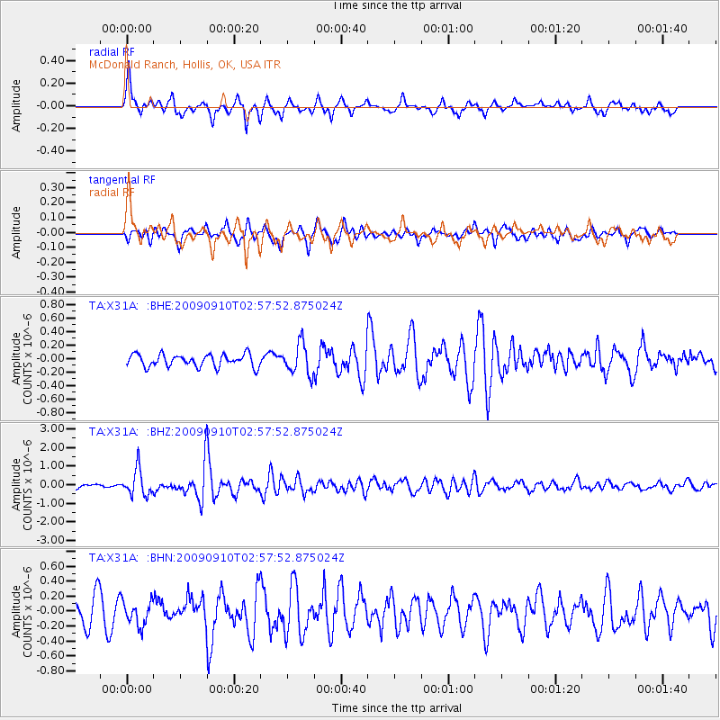
X31A McDonald Ranch, Hollis, OK, USA - Earthquake Result Viewer

| Earthquake location: |
Kuril Islands |
| Earthquake latitude/longitude: |
48.3/154.2 |
| Earthquake time(UTC): |
2009/09/10 (253) 02:46:50 GMT |
| Earthquake Depth: |
36 km |
| Earthquake Magnitude: |
6.0 MB, 5.5 MS, 6.0 MW, 5.8 MW |
| Earthquake Catalog/Contributor: |
WHDF/NEIC |
|
| Network: |
TA USArray Transportable Network (new EarthScope stations) |
| Station: |
X31A McDonald Ranch, Hollis, OK, USA |
| Lat/Lon: |
34.63 N/99.98 W |
| Elevation: |
514 m |
|
| Distance: |
74.3 deg |
| Az: |
55.508 deg |
| Baz: |
318.151 deg |
| Ray Param: |
0.052390687 |
| Estimated Moho Depth: |
45.0 km |
| Estimated Crust Vp/Vs: |
1.61 |
| Assumed Crust Vp: |
6.315 km/s |
| Estimated Crust Vs: |
3.929 km/s |
| Estimated Crust Poisson's Ratio: |
0.18 |
|
| Radial Match: |
82.109955 % |
| Radial Bump: |
400 |
| Transverse Match: |
66.122826 % |
| Transverse Bump: |
400 |
| SOD ConfigId: |
2622 |
| Insert Time: |
2010-03-06 00:18:23.983 +0000 |
| GWidth: |
2.5 |
| Max Bumps: |
400 |
| Tol: |
0.001 |
|
Signal To Noise
| Channel | StoN | STA | LTA |
| TA:X31A: :BHZ:20090910T02:57:52.875024Z | 5.674366 | 7.0707154E-7 | 1.2460802E-7 |
| TA:X31A: :BHN:20090910T02:57:52.875024Z | 0.99855787 | 1.5540346E-7 | 1.5562789E-7 |
| TA:X31A: :BHE:20090910T02:57:52.875024Z | 2.5030751 | 2.2796462E-7 | 9.107382E-8 |
| Arrivals |
| Ps | 4.5 SECOND |
| PpPs | 18 SECOND |
| PsPs/PpSs | 22 SECOND |


