You are here: Home > Network List > CI - Caltech Regional Seismic Network Stations List
> Station SMM Simmler, CA, USA > Earthquake Result Viewer
SMM Simmler, CA, USA - Earthquake Result Viewer
| Earthquake location: |
Near Islands, Aleutian Islands |
| Earthquake latitude/longitude: |
54.0/170.9 |
| Earthquake time(UTC): |
2017/06/02 (153) 22:24:47 GMT |
| Earthquake Depth: |
8.2 km |
| Earthquake Magnitude: |
6.8 Mww |
| Earthquake Catalog/Contributor: |
NEIC PDE/us |
|
| Network: |
CI Caltech Regional Seismic Network |
| Station: |
SMM Simmler, CA, USA |
| Lat/Lon: |
35.31 N/120.00 W |
| Elevation: |
599 m |
|
| Distance: |
50.4 deg |
| Az: |
82.257 deg |
| Baz: |
314.373 deg |
| Ray Param: |
0.06805761 |
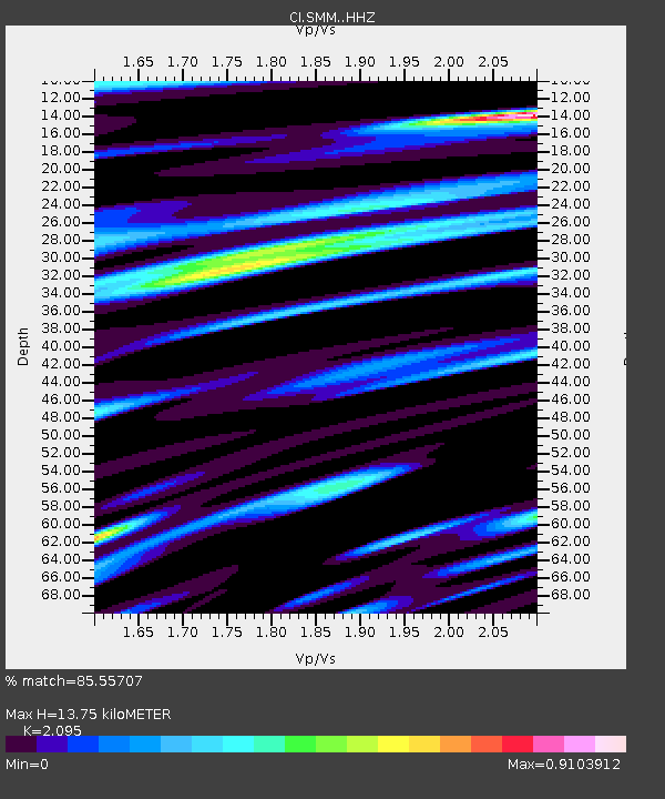
| Estimated Moho Depth: |
13.75 km |
| Estimated Crust Vp/Vs: |
2.10 |
| Assumed Crust Vp: |
6.1 km/s |
| Estimated Crust Vs: |
2.912 km/s |
| Estimated Crust Poisson's Ratio: |
0.35 |
|
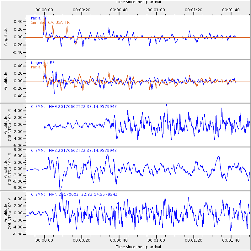
| Radial Match: |
85.55707 % |
| Radial Bump: |
400 |
| Transverse Match: |
78.91568 % |
| Transverse Bump: |
400 |
| SOD ConfigId: |
13570011 |
| Insert Time: |
2019-04-28 03:06:43.313 +0000 |
| GWidth: |
2.5 |
| Max Bumps: |
400 |
| Tol: |
0.001 |
|
Signal To Noise
| Channel | StoN | STA | LTA |
| CI:SMM: :HHZ:20170602T22:33:14.957994Z | 7.068152 | 2.5514103E-6 | 3.6097273E-7 |
| CI:SMM: :HHN:20170602T22:33:14.957994Z | 3.2606585 | 1.3004714E-6 | 3.9883702E-7 |
| CI:SMM: :HHE:20170602T22:33:14.957994Z | 2.1251585 | 1.1011458E-6 | 5.181476E-7 |
| Arrivals |
| Ps | 2.6 SECOND |
| PpPs | 6.7 SECOND |
| PsPs/PpSs | 9.3 SECOND |


