You are here: Home > Network List > TA - USArray Transportable Network (new EarthScope stations) Stations List
> Station X31A McDonald Ranch, Hollis, OK, USA > Earthquake Result Viewer
X31A McDonald Ranch, Hollis, OK, USA - Earthquake Result Viewer

| Earthquake location: |
Northern Mid-Atlantic Ridge |
| Earthquake latitude/longitude: |
23.9/-46.1 |
| Earthquake time(UTC): |
2009/06/06 (157) 20:33:28 GMT |
| Earthquake Depth: |
14 km |
| Earthquake Magnitude: |
6.0 MB, 5.7 MS, 6.0 MW, 6.0 MW |
| Earthquake Catalog/Contributor: |
WHDF/NEIC |
|
| Network: |
TA USArray Transportable Network (new EarthScope stations) |
| Station: |
X31A McDonald Ranch, Hollis, OK, USA |
| Lat/Lon: |
34.63 N/99.98 W |
| Elevation: |
514 m |
|
| Distance: |
47.7 deg |
| Az: |
295.824 deg |
| Baz: |
87.955 deg |
| Ray Param: |
0.069795854 |
| Estimated Moho Depth: |
54.0 km |
| Estimated Crust Vp/Vs: |
1.65 |
| Assumed Crust Vp: |
6.315 km/s |
| Estimated Crust Vs: |
3.822 km/s |
| Estimated Crust Poisson's Ratio: |
0.21 |
|
| Radial Match: |
82.48554 % |
| Radial Bump: |
400 |
| Transverse Match: |
66.57039 % |
| Transverse Bump: |
400 |
| SOD ConfigId: |
2648 |
| Insert Time: |
2010-03-06 00:18:30.317 +0000 |
| GWidth: |
2.5 |
| Max Bumps: |
400 |
| Tol: |
0.001 |
|
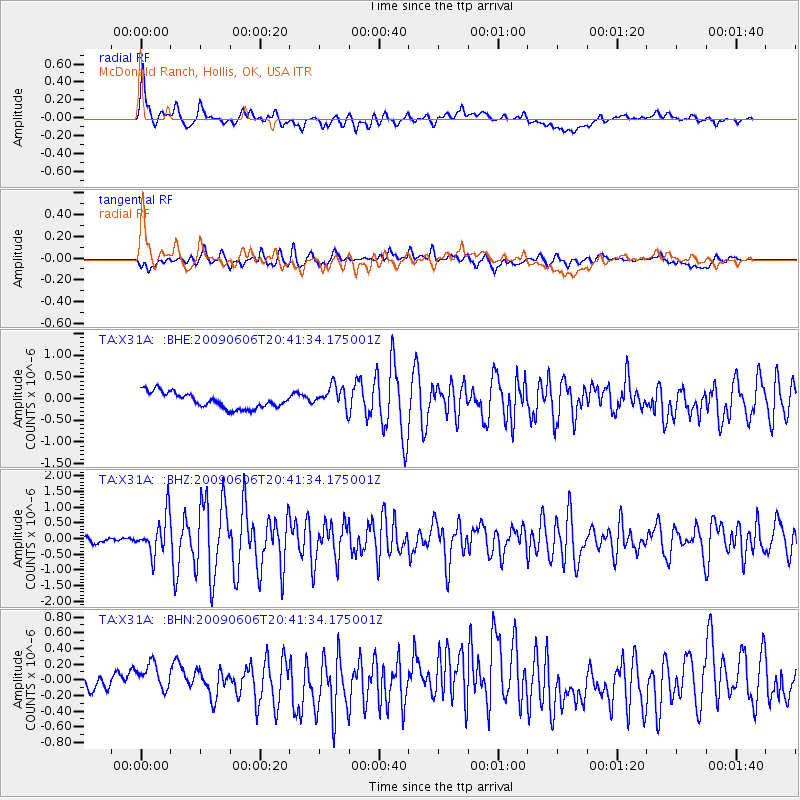
Signal To Noise
| Channel | StoN | STA | LTA |
| TA:X31A: :BHZ:20090606T20:41:34.175001Z | 8.487643 | 6.140863E-7 | 7.235062E-8 |
| TA:X31A: :BHN:20090606T20:41:34.175001Z | 1.596574 | 1.8522853E-7 | 1.1601626E-7 |
| TA:X31A: :BHE:20090606T20:41:34.175001Z | 1.5110406 | 2.7077527E-7 | 1.7919788E-7 |
| Arrivals |
| Ps | 5.9 SECOND |
| PpPs | 21 SECOND |
| PsPs/PpSs | 27 SECOND |


