You are here: Home > Network List > CN - Canadian National Seismograph Network Stations List
> Station A54 Misere, QC, CA > Earthquake Result Viewer
A54 Misere, QC, CA - Earthquake Result Viewer
| Earthquake location: |
Near Islands, Aleutian Islands |
| Earthquake latitude/longitude: |
54.0/170.9 |
| Earthquake time(UTC): |
2017/06/02 (153) 22:24:47 GMT |
| Earthquake Depth: |
8.2 km |
| Earthquake Magnitude: |
6.8 Mww |
| Earthquake Catalog/Contributor: |
NEIC PDE/us |
|
| Network: |
CN Canadian National Seismograph Network |
| Station: |
A54 Misere, QC, CA |
| Lat/Lon: |
47.46 N/70.41 W |
| Elevation: |
377 m |
|
| Distance: |
66.4 deg |
| Az: |
40.534 deg |
| Baz: |
325.598 deg |
| Ray Param: |
0.05766938 |
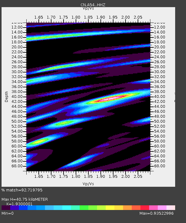
| Estimated Moho Depth: |
40.75 km |
| Estimated Crust Vp/Vs: |
1.93 |
| Assumed Crust Vp: |
6.61 km/s |
| Estimated Crust Vs: |
3.425 km/s |
| Estimated Crust Poisson's Ratio: |
0.32 |
|
| Radial Match: |
92.719795 % |
| Radial Bump: |
370 |
| Transverse Match: |
84.8951 % |
| Transverse Bump: |
400 |
| SOD ConfigId: |
13570011 |
| Insert Time: |
2019-04-28 03:06:56.461 +0000 |
| GWidth: |
2.5 |
| Max Bumps: |
400 |
| Tol: |
0.001 |
|

Signal To Noise
| Channel | StoN | STA | LTA |
| CN:A54: :HHZ:20170602T22:35:05.889971Z | 19.42058 | 1.6348657E-6 | 8.4182126E-8 |
| CN:A54: :HHN:20170602T22:35:05.889971Z | 5.3301606 | 5.635559E-7 | 1.0572962E-7 |
| CN:A54: :HHE:20170602T22:35:05.889971Z | 4.779497 | 4.5151862E-7 | 9.44699E-8 |
| Arrivals |
| Ps | 6.0 SECOND |
| PpPs | 17 SECOND |
| PsPs/PpSs | 23 SECOND |


