You are here: Home > Network List > CN - Canadian National Seismograph Network Stations List
> Station CBB Campbell River, BC, CA > Earthquake Result Viewer
CBB Campbell River, BC, CA - Earthquake Result Viewer
| Earthquake location: |
Near Islands, Aleutian Islands |
| Earthquake latitude/longitude: |
54.0/170.9 |
| Earthquake time(UTC): |
2017/06/02 (153) 22:24:47 GMT |
| Earthquake Depth: |
8.2 km |
| Earthquake Magnitude: |
6.8 Mww |
| Earthquake Catalog/Contributor: |
NEIC PDE/us |
|
| Network: |
CN Canadian National Seismograph Network |
| Station: |
CBB Campbell River, BC, CA |
| Lat/Lon: |
50.03 N/125.37 W |
| Elevation: |
277 m |
|
| Distance: |
38.2 deg |
| Az: |
69.138 deg |
| Baz: |
301.259 deg |
| Ray Param: |
0.07568583 |
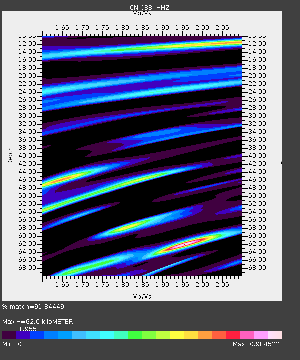
| Estimated Moho Depth: |
62.0 km |
| Estimated Crust Vp/Vs: |
1.96 |
| Assumed Crust Vp: |
6.566 km/s |
| Estimated Crust Vs: |
3.359 km/s |
| Estimated Crust Poisson's Ratio: |
0.32 |
|
| Radial Match: |
91.84449 % |
| Radial Bump: |
355 |
| Transverse Match: |
71.62285 % |
| Transverse Bump: |
400 |
| SOD ConfigId: |
13570011 |
| Insert Time: |
2019-04-28 03:07:06.058 +0000 |
| GWidth: |
2.5 |
| Max Bumps: |
400 |
| Tol: |
0.001 |
|

Signal To Noise
| Channel | StoN | STA | LTA |
| CN:CBB: :HHZ:20170602T22:31:37.390001Z | 11.463094 | 2.5401146E-6 | 2.2159067E-7 |
| CN:CBB: :HHN:20170602T22:31:37.390001Z | 5.029327 | 9.774265E-7 | 1.9434538E-7 |
| CN:CBB: :HHE:20170602T22:31:37.390001Z | 5.38022 | 1.3791531E-6 | 2.563377E-7 |
| Arrivals |
| Ps | 9.7 SECOND |
| PpPs | 26 SECOND |
| PsPs/PpSs | 36 SECOND |


