You are here: Home > Network List > CN - Canadian National Seismograph Network Stations List
> Station SYMB Survey Mountain, BC, CA > Earthquake Result Viewer
SYMB Survey Mountain, BC, CA - Earthquake Result Viewer
| Earthquake location: |
Near Islands, Aleutian Islands |
| Earthquake latitude/longitude: |
54.0/170.9 |
| Earthquake time(UTC): |
2017/06/02 (153) 22:24:47 GMT |
| Earthquake Depth: |
8.2 km |
| Earthquake Magnitude: |
6.8 Mww |
| Earthquake Catalog/Contributor: |
NEIC PDE/us |
|
| Network: |
CN Canadian National Seismograph Network |
| Station: |
SYMB Survey Mountain, BC, CA |
| Lat/Lon: |
48.56 N/123.80 W |
| Elevation: |
945 m |
|
| Distance: |
39.9 deg |
| Az: |
70.246 deg |
| Baz: |
303.303 deg |
| Ray Param: |
0.07472586 |
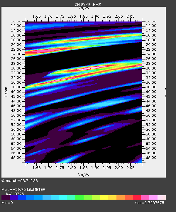
| Estimated Moho Depth: |
29.75 km |
| Estimated Crust Vp/Vs: |
1.88 |
| Assumed Crust Vp: |
6.566 km/s |
| Estimated Crust Vs: |
3.497 km/s |
| Estimated Crust Poisson's Ratio: |
0.30 |
|
| Radial Match: |
93.74138 % |
| Radial Bump: |
356 |
| Transverse Match: |
86.550964 % |
| Transverse Bump: |
400 |
| SOD ConfigId: |
13570011 |
| Insert Time: |
2019-04-28 03:07:55.229 +0000 |
| GWidth: |
2.5 |
| Max Bumps: |
400 |
| Tol: |
0.001 |
|

Signal To Noise
| Channel | StoN | STA | LTA |
| CN:SYMB: :HHZ:20170602T22:31:51.210009Z | 18.77255 | 3.0992026E-6 | 1.6509225E-7 |
| CN:SYMB: :HHN:20170602T22:31:51.210009Z | 5.8581767 | 1.0543016E-6 | 1.7997094E-7 |
| CN:SYMB: :HHE:20170602T22:31:51.210009Z | 11.271781 | 1.777989E-6 | 1.5773807E-7 |
| Arrivals |
| Ps | 4.3 SECOND |
| PpPs | 12 SECOND |
| PsPs/PpSs | 16 SECOND |


