You are here: Home > Network List > TA - USArray Transportable Network (new EarthScope stations) Stations List
> Station X31A McDonald Ranch, Hollis, OK, USA > Earthquake Result Viewer
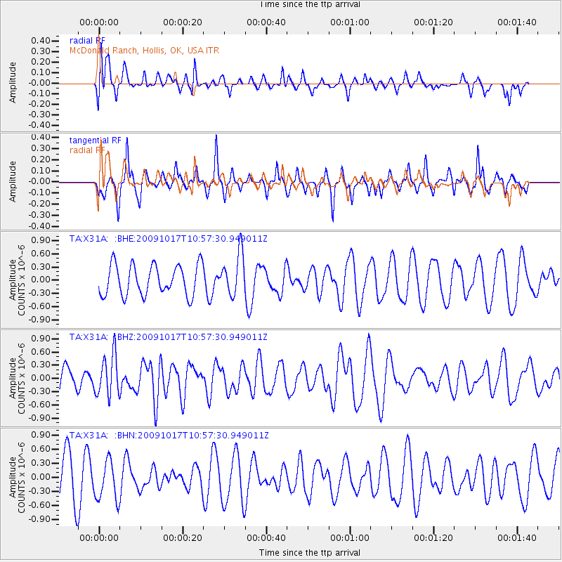
X31A McDonald Ranch, Hollis, OK, USA - Earthquake Result Viewer
*The percent match for this event was below the threshold and hence no stack was calculated.
| Earthquake location: |
Samoa Islands Region |
| Earthquake latitude/longitude: |
-16.4/-172.0 |
| Earthquake time(UTC): |
2009/10/17 (290) 10:45:26 GMT |
| Earthquake Depth: |
10 km |
| Earthquake Magnitude: |
5.7 MB, 5.3 MS, 5.7 MW, 5.7 MW |
| Earthquake Catalog/Contributor: |
WHDF/NEIC |
|
| Network: |
TA USArray Transportable Network (new EarthScope stations) |
| Station: |
X31A McDonald Ranch, Hollis, OK, USA |
| Lat/Lon: |
34.63 N/99.98 W |
| Elevation: |
514 m |
|
| Distance: |
85.1 deg |
| Az: |
51.925 deg |
| Baz: |
246.413 deg |
| Ray Param: |
$rayparam |
*The percent match for this event was below the threshold and hence was not used in the summary stack. |
|
| Radial Match: |
61.557095 % |
| Radial Bump: |
400 |
| Transverse Match: |
53.751114 % |
| Transverse Bump: |
282 |
| SOD ConfigId: |
2622 |
| Insert Time: |
2010-03-06 00:19:16.495 +0000 |
| GWidth: |
2.5 |
| Max Bumps: |
400 |
| Tol: |
0.001 |
|
Signal To Noise
| Channel | StoN | STA | LTA |
| TA:X31A: :BHZ:20091017T10:57:30.949011Z | 2.0090055 | 4.706496E-7 | 2.3426993E-7 |
| TA:X31A: :BHN:20091017T10:57:30.949011Z | 0.7664157 | 4.2641028E-7 | 5.5636946E-7 |
| TA:X31A: :BHE:20091017T10:57:30.949011Z | 1.3941779 | 4.813065E-7 | 3.4522603E-7 |
| Arrivals |
| Ps | |
| PpPs | |
| PsPs/PpSs | |


