You are here: Home > Network List > GI - Red Sismologica Nacional- Guatemala Stations List
> Station GUNB GUNB > Earthquake Result Viewer
GUNB GUNB - Earthquake Result Viewer
| Earthquake location: |
Near Islands, Aleutian Islands |
| Earthquake latitude/longitude: |
54.0/170.9 |
| Earthquake time(UTC): |
2017/06/02 (153) 22:24:47 GMT |
| Earthquake Depth: |
8.2 km |
| Earthquake Magnitude: |
6.8 Mww |
| Earthquake Catalog/Contributor: |
NEIC PDE/us |
|
| Network: |
GI Red Sismologica Nacional- Guatemala |
| Station: |
GUNB GUNB |
| Lat/Lon: |
14.60 N/90.35 W |
| Elevation: |
2403 m |
|
| Distance: |
83.4 deg |
| Az: |
74.432 deg |
| Baz: |
324.054 deg |
| Ray Param: |
0.046235953 |
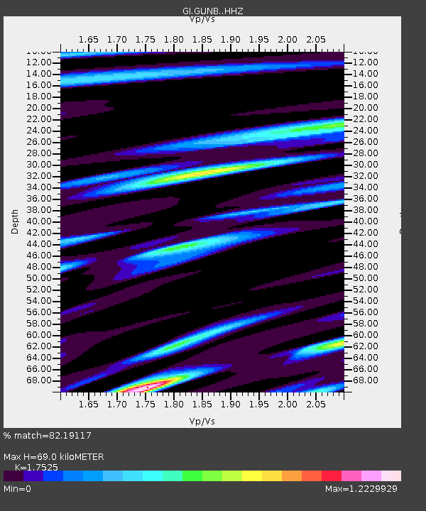
| Estimated Moho Depth: |
69.0 km |
| Estimated Crust Vp/Vs: |
1.75 |
| Assumed Crust Vp: |
6.566 km/s |
| Estimated Crust Vs: |
3.747 km/s |
| Estimated Crust Poisson's Ratio: |
0.26 |
|
| Radial Match: |
82.19117 % |
| Radial Bump: |
400 |
| Transverse Match: |
64.794205 % |
| Transverse Bump: |
400 |
| SOD ConfigId: |
13570011 |
| Insert Time: |
2019-04-28 03:08:56.041 +0000 |
| GWidth: |
2.5 |
| Max Bumps: |
400 |
| Tol: |
0.001 |
|

Signal To Noise
| Channel | StoN | STA | LTA |
| GI:GUNB: :HHZ:20170602T22:36:43.990007Z | 2.6299517 | 1.147233E-6 | 4.3621822E-7 |
| GI:GUNB: :HHN:20170602T22:36:43.990007Z | 1.4360049 | 6.021413E-7 | 4.1931705E-7 |
| GI:GUNB: :HHE:20170602T22:36:43.990007Z | 1.0618653 | 5.2029543E-7 | 4.899825E-7 |
| Arrivals |
| Ps | 8.1 SECOND |
| PpPs | 28 SECOND |
| PsPs/PpSs | 36 SECOND |


