You are here: Home > Network List > GI - Red Sismologica Nacional- Guatemala Stations List
> Station PETF Flores, Peten > Earthquake Result Viewer
PETF Flores, Peten - Earthquake Result Viewer
| Earthquake location: |
Near Islands, Aleutian Islands |
| Earthquake latitude/longitude: |
54.0/170.9 |
| Earthquake time(UTC): |
2017/06/02 (153) 22:24:47 GMT |
| Earthquake Depth: |
8.2 km |
| Earthquake Magnitude: |
6.8 Mww |
| Earthquake Catalog/Contributor: |
NEIC PDE/us |
|
| Network: |
GI Red Sismologica Nacional- Guatemala |
| Station: |
PETF Flores, Peten |
| Lat/Lon: |
16.92 N/89.87 W |
| Elevation: |
123 m |
|
| Distance: |
81.8 deg |
| Az: |
72.689 deg |
| Baz: |
323.958 deg |
| Ray Param: |
0.047349732 |
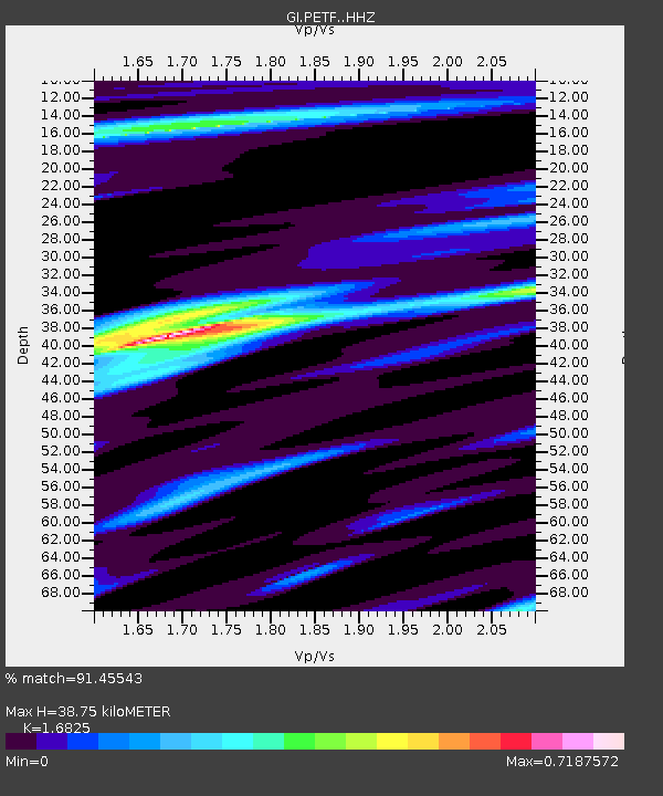
| Estimated Moho Depth: |
38.75 km |
| Estimated Crust Vp/Vs: |
1.68 |
| Assumed Crust Vp: |
6.302 km/s |
| Estimated Crust Vs: |
3.745 km/s |
| Estimated Crust Poisson's Ratio: |
0.23 |
|
| Radial Match: |
91.45543 % |
| Radial Bump: |
400 |
| Transverse Match: |
61.70464 % |
| Transverse Bump: |
400 |
| SOD ConfigId: |
13570011 |
| Insert Time: |
2019-04-28 03:08:56.546 +0000 |
| GWidth: |
2.5 |
| Max Bumps: |
400 |
| Tol: |
0.001 |
|

Signal To Noise
| Channel | StoN | STA | LTA |
| GI:PETF: :HHZ:20170602T22:36:35.700029Z | 6.8506684 | 1.2969265E-6 | 1.8931387E-7 |
| GI:PETF: :HHN:20170602T22:36:35.700029Z | 3.450092 | 5.507184E-7 | 1.5962426E-7 |
| GI:PETF: :HHE:20170602T22:36:35.700029Z | 2.4294348 | 3.0993286E-7 | 1.2757405E-7 |
| Arrivals |
| Ps | 4.3 SECOND |
| PpPs | 16 SECOND |
| PsPs/PpSs | 20 SECOND |


