You are here: Home > Network List > IU - Global Seismograph Network (GSN - IRIS/USGS) Stations List
> Station KMBO Kilima Mbogo, Kenya > Earthquake Result Viewer
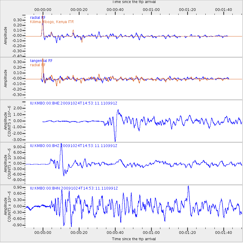
KMBO Kilima Mbogo, Kenya - Earthquake Result Viewer

| Earthquake location: |
Banda Sea |
| Earthquake latitude/longitude: |
-6.1/130.4 |
| Earthquake time(UTC): |
2009/10/24 (297) 14:40:43 GMT |
| Earthquake Depth: |
130 km |
| Earthquake Magnitude: |
6.7 MB, 6.9 MW, 6.9 MW |
| Earthquake Catalog/Contributor: |
WHDF/NEIC |
|
| Network: |
IU Global Seismograph Network (GSN - IRIS/USGS) |
| Station: |
KMBO Kilima Mbogo, Kenya |
| Lat/Lon: |
1.13 S/37.25 E |
| Elevation: |
1950 m |
|
| Distance: |
93.0 deg |
| Az: |
268.552 deg |
| Baz: |
96.161 deg |
| Ray Param: |
0.041275214 |
| Estimated Moho Depth: |
41.25 km |
| Estimated Crust Vp/Vs: |
1.73 |
| Assumed Crust Vp: |
6.601 km/s |
| Estimated Crust Vs: |
3.821 km/s |
| Estimated Crust Poisson's Ratio: |
0.25 |
|
| Radial Match: |
96.25996 % |
| Radial Bump: |
305 |
| Transverse Match: |
86.08466 % |
| Transverse Bump: |
400 |
| SOD ConfigId: |
1 |
| Insert Time: |
2010-02-19 00:56:02.739 +0000 |
| GWidth: |
2.5 |
| Max Bumps: |
400 |
| Tol: |
0.001 |
|
Signal To Noise
| Channel | StoN | STA | LTA |
| IU:KMBO:00:BHZ:20091024T14:53:11.110991Z | 13.070374 | 9.0078186E-7 | 6.8917835E-8 |
| IU:KMBO:00:BHN:20091024T14:53:11.110991Z | 0.9963589 | 7.4902886E-8 | 7.517661E-8 |
| IU:KMBO:00:BHE:20091024T14:53:11.110991Z | 3.4438162 | 2.16671E-7 | 6.291595E-8 |
| Arrivals |
| Ps | 4.6 SECOND |
| PpPs | 17 SECOND |
| PsPs/PpSs | 21 SECOND |


