You are here: Home > Network List > IU - Global Seismograph Network (GSN - IRIS/USGS) Stations List
> Station GRFO Grafenberg, Germany > Earthquake Result Viewer
GRFO Grafenberg, Germany - Earthquake Result Viewer
| Earthquake location: |
Near Islands, Aleutian Islands |
| Earthquake latitude/longitude: |
54.0/170.9 |
| Earthquake time(UTC): |
2017/06/02 (153) 22:24:47 GMT |
| Earthquake Depth: |
8.2 km |
| Earthquake Magnitude: |
6.8 Mww |
| Earthquake Catalog/Contributor: |
NEIC PDE/us |
|
| Network: |
IU Global Seismograph Network (GSN - IRIS/USGS) |
| Station: |
GRFO Grafenberg, Germany |
| Lat/Lon: |
49.69 N/11.22 E |
| Elevation: |
384 m |
|
| Distance: |
75.2 deg |
| Az: |
346.52 deg |
| Baz: |
12.226 deg |
| Ray Param: |
0.051801186 |
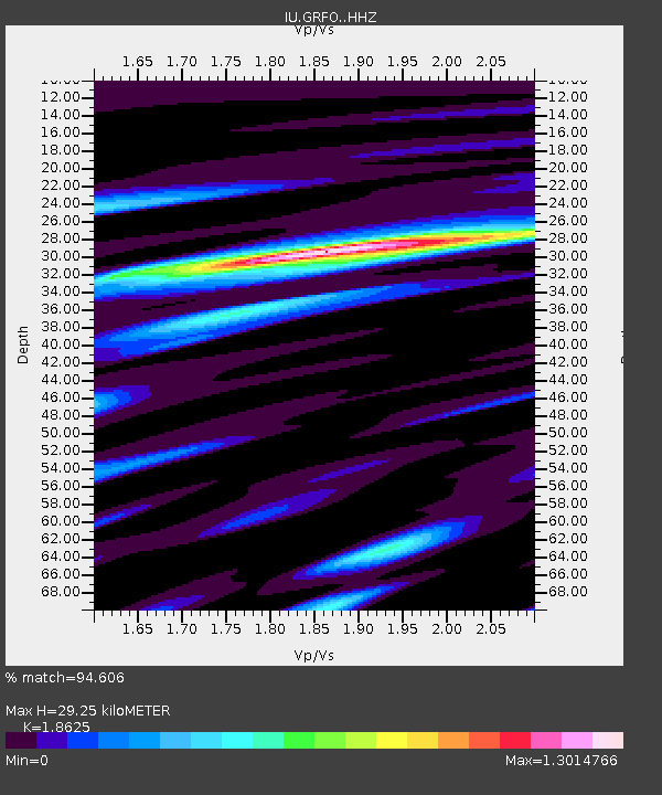
| Estimated Moho Depth: |
29.25 km |
| Estimated Crust Vp/Vs: |
1.86 |
| Assumed Crust Vp: |
6.182 km/s |
| Estimated Crust Vs: |
3.319 km/s |
| Estimated Crust Poisson's Ratio: |
0.30 |
|
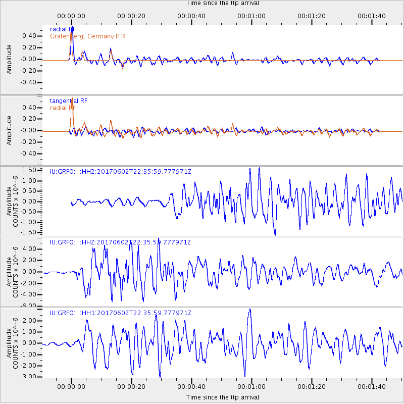
| Radial Match: |
94.606 % |
| Radial Bump: |
375 |
| Transverse Match: |
85.436356 % |
| Transverse Bump: |
400 |
| SOD ConfigId: |
13570011 |
| Insert Time: |
2019-04-28 03:09:26.689 +0000 |
| GWidth: |
2.5 |
| Max Bumps: |
400 |
| Tol: |
0.001 |
|
Signal To Noise
| Channel | StoN | STA | LTA |
| IU:GRFO: :HHZ:20170602T22:35:59.777971Z | 15.855717 | 1.3255109E-6 | 8.3598295E-8 |
| IU:GRFO: :HH1:20170602T22:35:59.777971Z | 4.5667114 | 4.2906888E-7 | 9.395576E-8 |
| IU:GRFO: :HH2:20170602T22:35:59.777971Z | 2.3330226 | 2.5458212E-7 | 1.0912115E-7 |
| Arrivals |
| Ps | 4.2 SECOND |
| PpPs | 13 SECOND |
| PsPs/PpSs | 17 SECOND |


