You are here: Home > Network List > IU - Global Seismograph Network (GSN - IRIS/USGS) Stations List
> Station KBL Kabul, Afghanistan > Earthquake Result Viewer
KBL Kabul, Afghanistan - Earthquake Result Viewer
| Earthquake location: |
Near Islands, Aleutian Islands |
| Earthquake latitude/longitude: |
54.0/170.9 |
| Earthquake time(UTC): |
2017/06/02 (153) 22:24:47 GMT |
| Earthquake Depth: |
8.2 km |
| Earthquake Magnitude: |
6.8 Mww |
| Earthquake Catalog/Contributor: |
NEIC PDE/us |
|
| Network: |
IU Global Seismograph Network (GSN - IRIS/USGS) |
| Station: |
KBL Kabul, Afghanistan |
| Lat/Lon: |
34.54 N/69.04 E |
| Elevation: |
1920 m |
|
| Distance: |
69.2 deg |
| Az: |
300.192 deg |
| Baz: |
38.15 deg |
| Ray Param: |
0.055827904 |
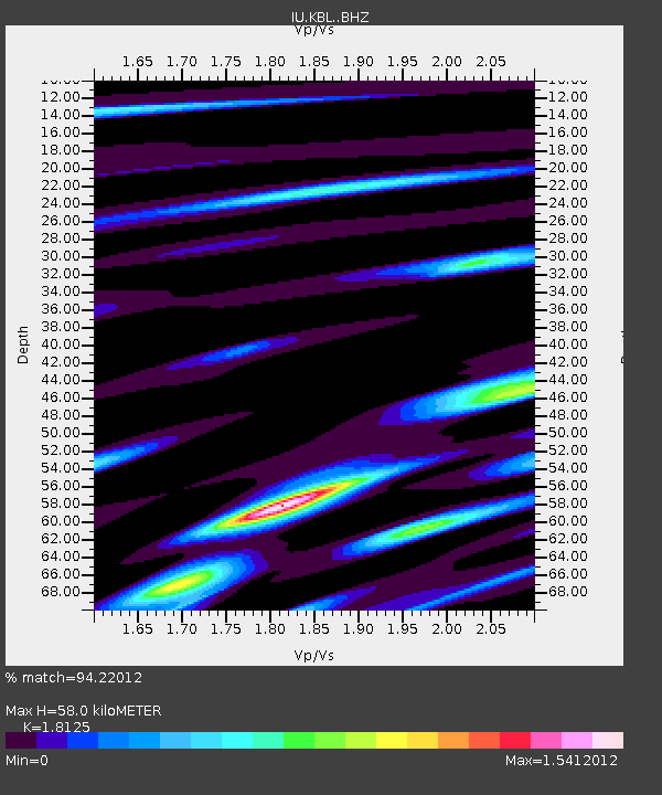
| Estimated Moho Depth: |
58.0 km |
| Estimated Crust Vp/Vs: |
1.81 |
| Assumed Crust Vp: |
6.641 km/s |
| Estimated Crust Vs: |
3.664 km/s |
| Estimated Crust Poisson's Ratio: |
0.28 |
|
| Radial Match: |
94.22012 % |
| Radial Bump: |
400 |
| Transverse Match: |
85.93294 % |
| Transverse Bump: |
400 |
| SOD ConfigId: |
13570011 |
| Insert Time: |
2019-04-28 03:09:27.241 +0000 |
| GWidth: |
2.5 |
| Max Bumps: |
400 |
| Tol: |
0.001 |
|
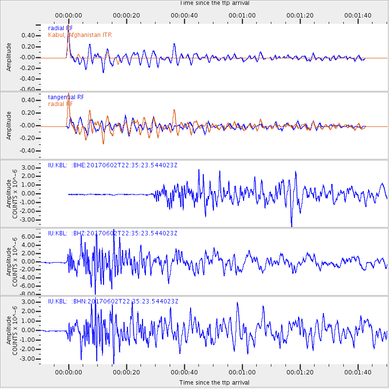
Signal To Noise
| Channel | StoN | STA | LTA |
| IU:KBL: :BHZ:20170602T22:35:23.544023Z | 49.82636 | 2.1022877E-6 | 4.219228E-8 |
| IU:KBL: :BHN:20170602T22:35:23.544023Z | 17.539898 | 8.742296E-7 | 4.9842342E-8 |
| IU:KBL: :BHE:20170602T22:35:23.544023Z | 19.829346 | 5.1680564E-7 | 2.6062667E-8 |
| Arrivals |
| Ps | 7.4 SECOND |
| PpPs | 24 SECOND |
| PsPs/PpSs | 31 SECOND |


