You are here: Home > Network List > JP - Japan Meteorological Agency Seismic Network Stations List
> Station JOW Okinawa Kunigami > Earthquake Result Viewer
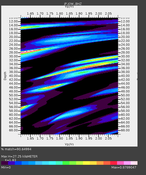
JOW Okinawa Kunigami - Earthquake Result Viewer
| Earthquake location: |
Near Islands, Aleutian Islands |
| Earthquake latitude/longitude: |
54.0/170.9 |
| Earthquake time(UTC): |
2017/06/02 (153) 22:24:47 GMT |
| Earthquake Depth: |
8.2 km |
| Earthquake Magnitude: |
6.8 Mww |
| Earthquake Catalog/Contributor: |
NEIC PDE/us |
|
| Network: |
JP Japan Meteorological Agency Seismic Network |
| Station: |
JOW Okinawa Kunigami |
| Lat/Lon: |
26.84 N/128.27 E |
| Elevation: |
220 m |
|
| Distance: |
41.4 deg |
| Az: |
246.287 deg |
| Baz: |
37.194 deg |
| Ray Param: |
0.073834024 |
| Estimated Moho Depth: |
27.25 km |
| Estimated Crust Vp/Vs: |
1.63 |
| Assumed Crust Vp: |
6.183 km/s |
| Estimated Crust Vs: |
3.793 km/s |
| Estimated Crust Poisson's Ratio: |
0.20 |
|
| Radial Match: |
90.64994 % |
| Radial Bump: |
382 |
| Transverse Match: |
78.985085 % |
| Transverse Bump: |
400 |
| SOD ConfigId: |
13570011 |
| Insert Time: |
2019-04-28 03:09:34.596 +0000 |
| GWidth: |
2.5 |
| Max Bumps: |
400 |
| Tol: |
0.001 |
|

Signal To Noise
| Channel | StoN | STA | LTA |
| JP:JOW: :BHZ:20170602T22:32:03.550005Z | 7.9733706 | 2.0343562E-6 | 2.5514382E-7 |
| JP:JOW: :BHN:20170602T22:32:03.550005Z | 1.8516433 | 1.0326302E-6 | 5.5768305E-7 |
| JP:JOW: :BHE:20170602T22:32:03.550005Z | 2.3372273 | 8.211282E-7 | 3.5132578E-7 |
| Arrivals |
| Ps | 3.0 SECOND |
| PpPs | 11 SECOND |
| PsPs/PpSs | 14 SECOND |


