You are here: Home > Network List > LD - Lamont-Doherty Cooperative Seismographic Network Stations List
> Station TUPA Temple University, Pennsylvania > Earthquake Result Viewer
TUPA Temple University, Pennsylvania - Earthquake Result Viewer
| Earthquake location: |
Near Islands, Aleutian Islands |
| Earthquake latitude/longitude: |
54.0/170.9 |
| Earthquake time(UTC): |
2017/06/02 (153) 22:24:47 GMT |
| Earthquake Depth: |
8.2 km |
| Earthquake Magnitude: |
6.8 Mww |
| Earthquake Catalog/Contributor: |
NEIC PDE/us |
|
| Network: |
LD Lamont-Doherty Cooperative Seismographic Network |
| Station: |
TUPA Temple University, Pennsylvania |
| Lat/Lon: |
40.17 N/75.19 W |
| Elevation: |
112 m |
|
| Distance: |
70.4 deg |
| Az: |
48.048 deg |
| Baz: |
325.071 deg |
| Ray Param: |
0.055016536 |
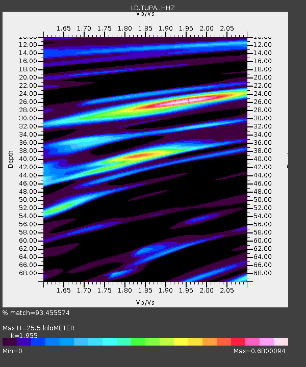
| Estimated Moho Depth: |
25.5 km |
| Estimated Crust Vp/Vs: |
1.96 |
| Assumed Crust Vp: |
6.283 km/s |
| Estimated Crust Vs: |
3.214 km/s |
| Estimated Crust Poisson's Ratio: |
0.32 |
|
| Radial Match: |
93.455574 % |
| Radial Bump: |
400 |
| Transverse Match: |
75.67625 % |
| Transverse Bump: |
400 |
| SOD ConfigId: |
13570011 |
| Insert Time: |
2019-04-28 03:10:26.790 +0000 |
| GWidth: |
2.5 |
| Max Bumps: |
400 |
| Tol: |
0.001 |
|
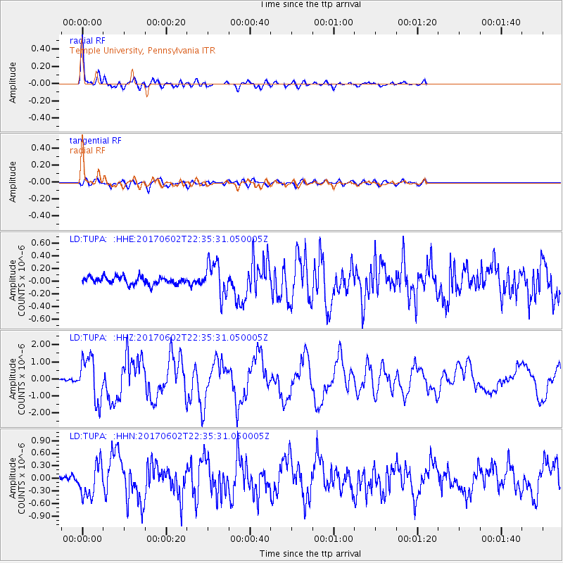
Signal To Noise
| Channel | StoN | STA | LTA |
| LD:TUPA: :HHZ:20170602T22:35:31.050005Z | 16.312525 | 1.2774055E-6 | 7.830826E-8 |
| LD:TUPA: :HHN:20170602T22:35:31.050005Z | 5.027498 | 3.982133E-7 | 7.920706E-8 |
| LD:TUPA: :HHE:20170602T22:35:31.050005Z | 4.5257525 | 2.6530856E-7 | 5.8621975E-8 |
| Arrivals |
| Ps | 4.0 SECOND |
| PpPs | 12 SECOND |
| PsPs/PpSs | 16 SECOND |


