You are here: Home > Network List > N4 - Central and EAstern US Network Stations List
> Station F63A Nahmakanta, Browneville, ME, USA > Earthquake Result Viewer
F63A Nahmakanta, Browneville, ME, USA - Earthquake Result Viewer
| Earthquake location: |
Near Islands, Aleutian Islands |
| Earthquake latitude/longitude: |
54.0/170.9 |
| Earthquake time(UTC): |
2017/06/02 (153) 22:24:47 GMT |
| Earthquake Depth: |
8.2 km |
| Earthquake Magnitude: |
6.8 Mww |
| Earthquake Catalog/Contributor: |
NEIC PDE/us |
|
| Network: |
N4 Central and EAstern US Network |
| Station: |
F63A Nahmakanta, Browneville, ME, USA |
| Lat/Lon: |
45.70 N/69.10 W |
| Elevation: |
386 m |
|
| Distance: |
68.3 deg |
| Az: |
40.78 deg |
| Baz: |
326.642 deg |
| Ray Param: |
0.056382656 |
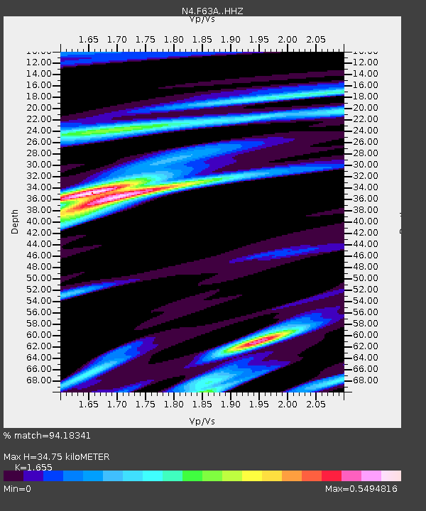
| Estimated Moho Depth: |
34.75 km |
| Estimated Crust Vp/Vs: |
1.65 |
| Assumed Crust Vp: |
6.419 km/s |
| Estimated Crust Vs: |
3.879 km/s |
| Estimated Crust Poisson's Ratio: |
0.21 |
|
| Radial Match: |
94.18341 % |
| Radial Bump: |
295 |
| Transverse Match: |
83.579544 % |
| Transverse Bump: |
400 |
| SOD ConfigId: |
13570011 |
| Insert Time: |
2019-04-28 03:11:07.626 +0000 |
| GWidth: |
2.5 |
| Max Bumps: |
400 |
| Tol: |
0.001 |
|

Signal To Noise
| Channel | StoN | STA | LTA |
| N4:F63A: :HHZ:20170602T22:35:18.279985Z | 13.371878 | 1.3475317E-6 | 1.00773555E-7 |
| N4:F63A: :HHN:20170602T22:35:18.279985Z | 5.8184714 | 5.149262E-7 | 8.8498545E-8 |
| N4:F63A: :HHE:20170602T22:35:18.279985Z | 2.8281722 | 2.613389E-7 | 9.2405585E-8 |
| Arrivals |
| Ps | 3.7 SECOND |
| PpPs | 14 SECOND |
| PsPs/PpSs | 17 SECOND |


