You are here: Home > Network List > TA - USArray Transportable Network (new EarthScope stations) Stations List
> Station W31A Holland Ranch, Erick, OK, USA > Earthquake Result Viewer
W31A Holland Ranch, Erick, OK, USA - Earthquake Result Viewer
| Earthquake location: |
Near Coast Of Venezuela |
| Earthquake latitude/longitude: |
10.7/-67.9 |
| Earthquake time(UTC): |
2009/09/12 (255) 20:06:24 GMT |
| Earthquake Depth: |
10 km |
| Earthquake Magnitude: |
6.3 MB, 6.4 MS, 6.3 MW, 6.3 MW |
| Earthquake Catalog/Contributor: |
WHDF/NEIC |
|
| Network: |
TA USArray Transportable Network (new EarthScope stations) |
| Station: |
W31A Holland Ranch, Erick, OK, USA |
| Lat/Lon: |
35.19 N/99.94 W |
| Elevation: |
644 m |
|
| Distance: |
38.0 deg |
| Az: |
315.085 deg |
| Baz: |
122.094 deg |
| Ray Param: |
0.075835936 |
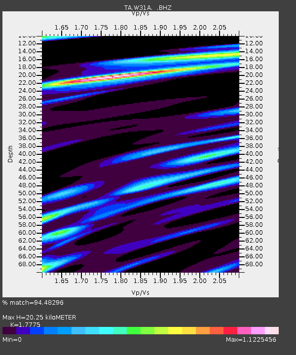
| Estimated Moho Depth: |
20.25 km |
| Estimated Crust Vp/Vs: |
1.78 |
| Assumed Crust Vp: |
6.315 km/s |
| Estimated Crust Vs: |
3.553 km/s |
| Estimated Crust Poisson's Ratio: |
0.27 |
|
| Radial Match: |
94.48296 % |
| Radial Bump: |
293 |
| Transverse Match: |
83.339966 % |
| Transverse Bump: |
400 |
| SOD ConfigId: |
2622 |
| Insert Time: |
2010-03-06 00:19:42.074 +0000 |
| GWidth: |
2.5 |
| Max Bumps: |
400 |
| Tol: |
0.001 |
|

Signal To Noise
| Channel | StoN | STA | LTA |
| TA:W31A: :BHZ:20090912T20:13:11.598986Z | 9.325343 | 1.0366518E-6 | 1.1116501E-7 |
| TA:W31A: :BHN:20090912T20:13:11.598986Z | 2.73331 | 3.0121242E-7 | 1.1020061E-7 |
| TA:W31A: :BHE:20090912T20:13:11.598986Z | 3.083983 | 6.835258E-7 | 2.2163735E-7 |
| Arrivals |
| Ps | 2.7 SECOND |
| PpPs | 8.3 SECOND |
| PsPs/PpSs | 11 SECOND |


