You are here: Home > Network List > TA - USArray Transportable Network (new EarthScope stations) Stations List
> Station W31A Holland Ranch, Erick, OK, USA > Earthquake Result Viewer
W31A Holland Ranch, Erick, OK, USA - Earthquake Result Viewer
| Earthquake location: |
Samoa Islands Region |
| Earthquake latitude/longitude: |
-15.5/-172.1 |
| Earthquake time(UTC): |
2009/09/29 (272) 17:48:10 GMT |
| Earthquake Depth: |
18 km |
| Earthquake Magnitude: |
7.1 MB, 8.1 MS, 8.1 MW, 8.0 MW |
| Earthquake Catalog/Contributor: |
WHDF/NEIC |
|
| Network: |
TA USArray Transportable Network (new EarthScope stations) |
| Station: |
W31A Holland Ranch, Erick, OK, USA |
| Lat/Lon: |
35.19 N/99.94 W |
| Elevation: |
644 m |
|
| Distance: |
84.8 deg |
| Az: |
51.521 deg |
| Baz: |
247.141 deg |
| Ray Param: |
0.04517474 |
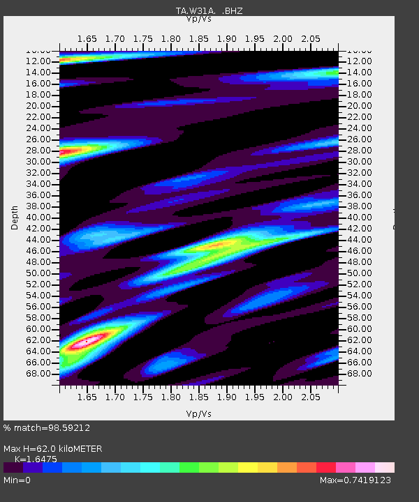
| Estimated Moho Depth: |
62.0 km |
| Estimated Crust Vp/Vs: |
1.65 |
| Assumed Crust Vp: |
6.315 km/s |
| Estimated Crust Vs: |
3.833 km/s |
| Estimated Crust Poisson's Ratio: |
0.21 |
|
| Radial Match: |
98.59212 % |
| Radial Bump: |
400 |
| Transverse Match: |
95.640755 % |
| Transverse Bump: |
400 |
| SOD ConfigId: |
2622 |
| Insert Time: |
2010-03-06 00:19:42.971 +0000 |
| GWidth: |
2.5 |
| Max Bumps: |
400 |
| Tol: |
0.001 |
|

Signal To Noise
| Channel | StoN | STA | LTA |
| TA:W31A: :BHZ:20090929T18:00:12.974009Z | 19.582245 | 3.202507E-6 | 1.6354137E-7 |
| TA:W31A: :BHN:20090929T18:00:12.974009Z | 4.8673115 | 5.1107526E-7 | 1.05001554E-7 |
| TA:W31A: :BHE:20090929T18:00:12.974009Z | 5.0962787 | 1.0234442E-6 | 2.0082187E-7 |
| Arrivals |
| Ps | 6.5 SECOND |
| PpPs | 25 SECOND |
| PsPs/PpSs | 32 SECOND |


