You are here: Home > Network List > TA - USArray Transportable Network (new EarthScope stations) Stations List
> Station W31A Holland Ranch, Erick, OK, USA > Earthquake Result Viewer
W31A Holland Ranch, Erick, OK, USA - Earthquake Result Viewer
| Earthquake location: |
Galapagos Triple Junction Region |
| Earthquake latitude/longitude: |
3.3/-103.8 |
| Earthquake time(UTC): |
2009/10/15 (288) 17:48:21 GMT |
| Earthquake Depth: |
10 km |
| Earthquake Magnitude: |
5.9 MB, 5.7 MS, 6.0 MW, 6.0 MW |
| Earthquake Catalog/Contributor: |
WHDF/NEIC |
|
| Network: |
TA USArray Transportable Network (new EarthScope stations) |
| Station: |
W31A Holland Ranch, Erick, OK, USA |
| Lat/Lon: |
35.19 N/99.94 W |
| Elevation: |
644 m |
|
| Distance: |
32.0 deg |
| Az: |
6.01 deg |
| Baz: |
187.332 deg |
| Ray Param: |
0.07885559 |
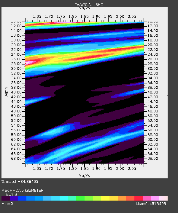
| Estimated Moho Depth: |
27.5 km |
| Estimated Crust Vp/Vs: |
1.60 |
| Assumed Crust Vp: |
6.315 km/s |
| Estimated Crust Vs: |
3.947 km/s |
| Estimated Crust Poisson's Ratio: |
0.18 |
|
| Radial Match: |
84.36465 % |
| Radial Bump: |
400 |
| Transverse Match: |
63.63361 % |
| Transverse Bump: |
343 |
| SOD ConfigId: |
2622 |
| Insert Time: |
2010-03-06 00:19:44.650 +0000 |
| GWidth: |
2.5 |
| Max Bumps: |
400 |
| Tol: |
0.001 |
|

Signal To Noise
| Channel | StoN | STA | LTA |
| TA:W31A: :BHZ:20091015T17:54:17.175004Z | 2.281876 | 2.317691E-6 | 1.0156955E-6 |
| TA:W31A: :BHN:20091015T17:54:17.175004Z | 1.2117711 | 9.794796E-7 | 8.0830415E-7 |
| TA:W31A: :BHE:20091015T17:54:17.175004Z | 0.8049797 | 9.3586766E-7 | 1.1625979E-6 |
| Arrivals |
| Ps | 2.8 SECOND |
| PpPs | 10 SECOND |
| PsPs/PpSs | 13 SECOND |


