You are here: Home > Network List > US - United States National Seismic Network Stations List
> Station PKME Peaks-Kenny State Park, Maine, USA > Earthquake Result Viewer
PKME Peaks-Kenny State Park, Maine, USA - Earthquake Result Viewer

| Earthquake location: |
Near Coast Of Chiapas, Mexico |
| Earthquake latitude/longitude: |
15.9/-93.4 |
| Earthquake time(UTC): |
2015/12/17 (351) 19:49:54 GMT |
| Earthquake Depth: |
97 km |
| Earthquake Magnitude: |
6.4 MWB, 6.6 MI |
| Earthquake Catalog/Contributor: |
NEIC PDE/NEIC COMCAT |
|
| Network: |
US United States National Seismic Network |
| Station: |
PKME Peaks-Kenny State Park, Maine, USA |
| Lat/Lon: |
45.26 N/69.29 W |
| Elevation: |
108 m |
|
| Distance: |
35.6 deg |
| Az: |
29.72 deg |
| Baz: |
222.493 deg |
| Ray Param: |
0.076809436 |
| Estimated Moho Depth: |
25.75 km |
| Estimated Crust Vp/Vs: |
2.00 |
| Assumed Crust Vp: |
6.419 km/s |
| Estimated Crust Vs: |
3.21 km/s |
| Estimated Crust Poisson's Ratio: |
0.33 |
|
| Radial Match: |
92.6291 % |
| Radial Bump: |
190 |
| Transverse Match: |
76.72406 % |
| Transverse Bump: |
337 |
| SOD ConfigId: |
1259291 |
| Insert Time: |
2015-12-31 20:22:47.681 +0000 |
| GWidth: |
2.5 |
| Max Bumps: |
400 |
| Tol: |
0.001 |
|
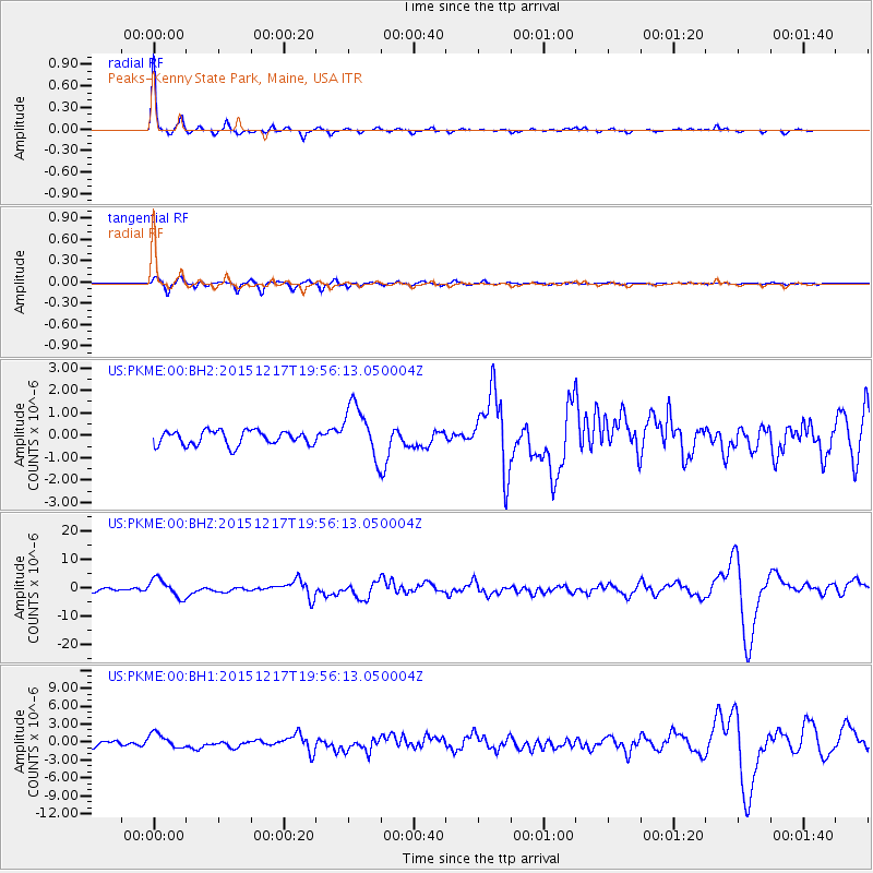
Signal To Noise
| Channel | StoN | STA | LTA |
| US:PKME:00:BHZ:20151217T19:56:13.050004Z | 5.4731455 | 3.1997313E-6 | 5.846239E-7 |
| US:PKME:00:BH1:20151217T19:56:13.050004Z | 2.639999 | 1.2382009E-6 | 4.6901567E-7 |
| US:PKME:00:BH2:20151217T19:56:13.050004Z | 3.7429647 | 1.1812486E-6 | 3.155917E-7 |
| Arrivals |
| Ps | 4.3 SECOND |
| PpPs | 11 SECOND |
| PsPs/PpSs | 16 SECOND |


