You are here: Home > Network List > TA - USArray Transportable Network (new EarthScope stations) Stations List
> Station W31A Holland Ranch, Erick, OK, USA > Earthquake Result Viewer
W31A Holland Ranch, Erick, OK, USA - Earthquake Result Viewer
| Earthquake location: |
Northern Mid-Atlantic Ridge |
| Earthquake latitude/longitude: |
23.9/-46.1 |
| Earthquake time(UTC): |
2009/06/06 (157) 20:33:28 GMT |
| Earthquake Depth: |
14 km |
| Earthquake Magnitude: |
6.0 MB, 5.7 MS, 6.0 MW, 6.0 MW |
| Earthquake Catalog/Contributor: |
WHDF/NEIC |
|
| Network: |
TA USArray Transportable Network (new EarthScope stations) |
| Station: |
W31A Holland Ranch, Erick, OK, USA |
| Lat/Lon: |
35.19 N/99.94 W |
| Elevation: |
644 m |
|
| Distance: |
47.7 deg |
| Az: |
296.572 deg |
| Baz: |
88.479 deg |
| Ray Param: |
0.06982487 |
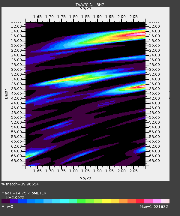
| Estimated Moho Depth: |
14.75 km |
| Estimated Crust Vp/Vs: |
2.10 |
| Assumed Crust Vp: |
6.315 km/s |
| Estimated Crust Vs: |
3.011 km/s |
| Estimated Crust Poisson's Ratio: |
0.35 |
|
| Radial Match: |
89.96654 % |
| Radial Bump: |
400 |
| Transverse Match: |
78.469475 % |
| Transverse Bump: |
400 |
| SOD ConfigId: |
2648 |
| Insert Time: |
2010-03-06 00:19:49.299 +0000 |
| GWidth: |
2.5 |
| Max Bumps: |
400 |
| Tol: |
0.001 |
|
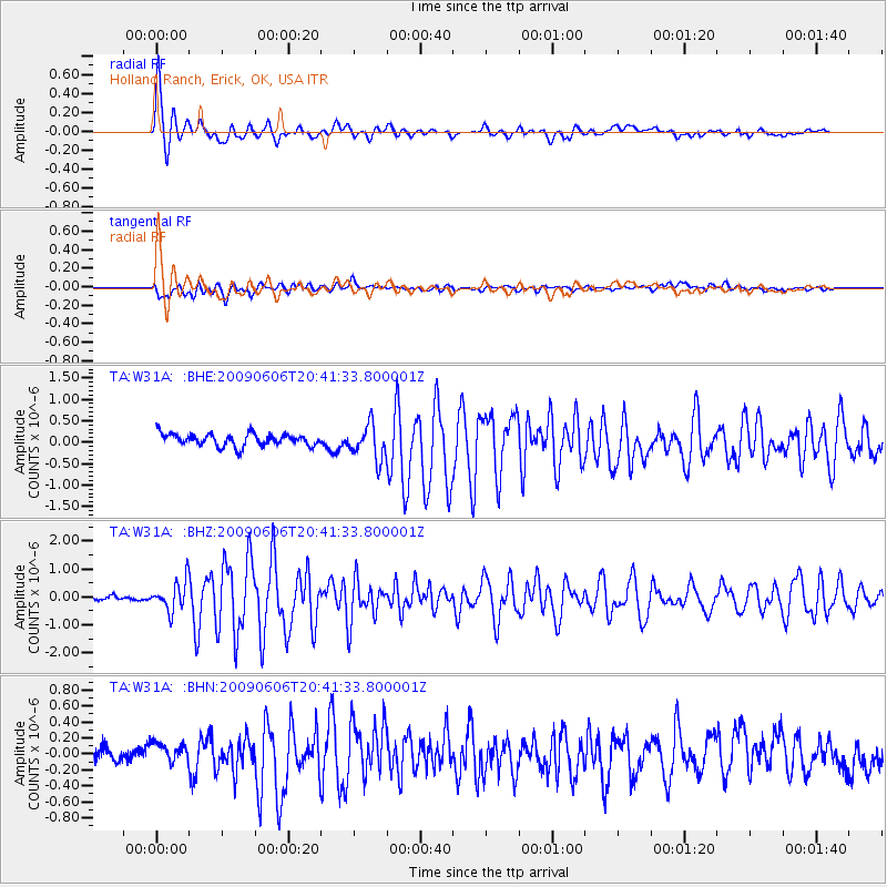
Signal To Noise
| Channel | StoN | STA | LTA |
| TA:W31A: :BHZ:20090606T20:41:33.800001Z | 5.1747355 | 5.276054E-7 | 1.0195793E-7 |
| TA:W31A: :BHN:20090606T20:41:33.800001Z | 1.4443208 | 1.3157813E-7 | 9.110035E-8 |
| TA:W31A: :BHE:20090606T20:41:33.800001Z | 2.8632703 | 4.0574315E-7 | 1.417062E-7 |
| Arrivals |
| Ps | 2.7 SECOND |
| PpPs | 6.9 SECOND |
| PsPs/PpSs | 9.6 SECOND |


