You are here: Home > Network List > N4 - Central and EAstern US Network Stations List
> Station L34B Svendsen Farm, Lyons, NE, USA > Earthquake Result Viewer
L34B Svendsen Farm, Lyons, NE, USA - Earthquake Result Viewer
| Earthquake location: |
Near Islands, Aleutian Islands |
| Earthquake latitude/longitude: |
54.0/170.9 |
| Earthquake time(UTC): |
2017/06/02 (153) 22:24:47 GMT |
| Earthquake Depth: |
8.2 km |
| Earthquake Magnitude: |
6.8 Mww |
| Earthquake Catalog/Contributor: |
NEIC PDE/us |
|
| Network: |
N4 Central and EAstern US Network |
| Station: |
L34B Svendsen Farm, Lyons, NE, USA |
| Lat/Lon: |
41.97 N/96.38 W |
| Elevation: |
414 m |
|
| Distance: |
58.9 deg |
| Az: |
60.495 deg |
| Baz: |
316.49 deg |
| Ray Param: |
0.06257158 |
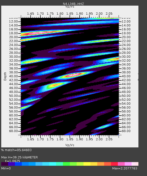
| Estimated Moho Depth: |
39.25 km |
| Estimated Crust Vp/Vs: |
1.86 |
| Assumed Crust Vp: |
6.498 km/s |
| Estimated Crust Vs: |
3.489 km/s |
| Estimated Crust Poisson's Ratio: |
0.30 |
|
| Radial Match: |
85.64683 % |
| Radial Bump: |
400 |
| Transverse Match: |
74.686195 % |
| Transverse Bump: |
400 |
| SOD ConfigId: |
13570011 |
| Insert Time: |
2019-04-28 03:11:31.024 +0000 |
| GWidth: |
2.5 |
| Max Bumps: |
400 |
| Tol: |
0.001 |
|

Signal To Noise
| Channel | StoN | STA | LTA |
| N4:L34B: :HHZ:20170602T22:34:15.920Z | 12.85994 | 2.716884E-6 | 2.1126723E-7 |
| N4:L34B: :HHN:20170602T22:34:15.920Z | 4.6491456 | 1.6141976E-6 | 3.4720307E-7 |
| N4:L34B: :HHE:20170602T22:34:15.920Z | 3.7547407 | 1.4328587E-6 | 3.816132E-7 |
| Arrivals |
| Ps | 5.5 SECOND |
| PpPs | 16 SECOND |
| PsPs/PpSs | 22 SECOND |


