You are here: Home > Network List > N4 - Central and EAstern US Network Stations List
> Station N33B J Bar K, Exeter, NE, USA > Earthquake Result Viewer
N33B J Bar K, Exeter, NE, USA - Earthquake Result Viewer
| Earthquake location: |
Near Islands, Aleutian Islands |
| Earthquake latitude/longitude: |
54.0/170.9 |
| Earthquake time(UTC): |
2017/06/02 (153) 22:24:47 GMT |
| Earthquake Depth: |
8.2 km |
| Earthquake Magnitude: |
6.8 Mww |
| Earthquake Catalog/Contributor: |
NEIC PDE/us |
|
| Network: |
N4 Central and EAstern US Network |
| Station: |
N33B J Bar K, Exeter, NE, USA |
| Lat/Lon: |
40.74 N/97.45 W |
| Elevation: |
482 m |
|
| Distance: |
59.2 deg |
| Az: |
62.165 deg |
| Baz: |
316.642 deg |
| Ray Param: |
0.062351063 |
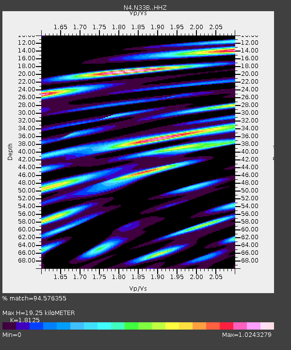
| Estimated Moho Depth: |
19.25 km |
| Estimated Crust Vp/Vs: |
1.81 |
| Assumed Crust Vp: |
6.498 km/s |
| Estimated Crust Vs: |
3.585 km/s |
| Estimated Crust Poisson's Ratio: |
0.28 |
|
| Radial Match: |
94.576355 % |
| Radial Bump: |
400 |
| Transverse Match: |
86.772865 % |
| Transverse Bump: |
400 |
| SOD ConfigId: |
13570011 |
| Insert Time: |
2019-04-28 03:11:43.316 +0000 |
| GWidth: |
2.5 |
| Max Bumps: |
400 |
| Tol: |
0.001 |
|

Signal To Noise
| Channel | StoN | STA | LTA |
| N4:N33B: :HHZ:20170602T22:34:18.240007Z | 29.547747 | 2.7968777E-6 | 9.465621E-8 |
| N4:N33B: :HHN:20170602T22:34:18.240007Z | 10.607527 | 1.9429249E-6 | 1.8316473E-7 |
| N4:N33B: :HHE:20170602T22:34:18.240007Z | 8.005805 | 1.3364946E-6 | 1.669407E-7 |
| Arrivals |
| Ps | 2.5 SECOND |
| PpPs | 7.9 SECOND |
| PsPs/PpSs | 10 SECOND |


