You are here: Home > Network List > N4 - Central and EAstern US Network Stations List
> Station U56A King, NC, USA > Earthquake Result Viewer
U56A King, NC, USA - Earthquake Result Viewer
| Earthquake location: |
Near Islands, Aleutian Islands |
| Earthquake latitude/longitude: |
54.0/170.9 |
| Earthquake time(UTC): |
2017/06/02 (153) 22:24:47 GMT |
| Earthquake Depth: |
8.2 km |
| Earthquake Magnitude: |
6.8 Mww |
| Earthquake Catalog/Contributor: |
NEIC PDE/us |
|
| Network: |
N4 Central and EAstern US Network |
| Station: |
U56A King, NC, USA |
| Lat/Lon: |
36.35 N/80.38 W |
| Elevation: |
363 m |
|
| Distance: |
71.1 deg |
| Az: |
53.92 deg |
| Baz: |
323.801 deg |
| Ray Param: |
0.05453878 |
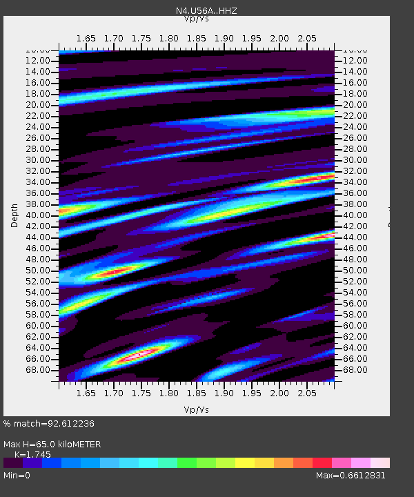
| Estimated Moho Depth: |
65.0 km |
| Estimated Crust Vp/Vs: |
1.75 |
| Assumed Crust Vp: |
6.159 km/s |
| Estimated Crust Vs: |
3.529 km/s |
| Estimated Crust Poisson's Ratio: |
0.26 |
|
| Radial Match: |
92.612236 % |
| Radial Bump: |
400 |
| Transverse Match: |
72.9439 % |
| Transverse Bump: |
400 |
| SOD ConfigId: |
13570011 |
| Insert Time: |
2019-04-28 03:12:23.534 +0000 |
| GWidth: |
2.5 |
| Max Bumps: |
400 |
| Tol: |
0.001 |
|

Signal To Noise
| Channel | StoN | STA | LTA |
| N4:U56A: :HHZ:20170602T22:35:35.43001Z | 18.287846 | 1.431689E-6 | 7.828637E-8 |
| N4:U56A: :HHN:20170602T22:35:35.43001Z | 4.7434807 | 4.5397175E-7 | 9.570435E-8 |
| N4:U56A: :HHE:20170602T22:35:35.43001Z | 3.5827925 | 4.5580475E-7 | 1.2722053E-7 |
| Arrivals |
| Ps | 8.1 SECOND |
| PpPs | 28 SECOND |
| PsPs/PpSs | 36 SECOND |


