You are here: Home > Network List > N4 - Central and EAstern US Network Stations List
> Station V52A Sevierville, TN, USA > Earthquake Result Viewer
V52A Sevierville, TN, USA - Earthquake Result Viewer
| Earthquake location: |
Near Islands, Aleutian Islands |
| Earthquake latitude/longitude: |
54.0/170.9 |
| Earthquake time(UTC): |
2017/06/02 (153) 22:24:47 GMT |
| Earthquake Depth: |
8.2 km |
| Earthquake Magnitude: |
6.8 Mww |
| Earthquake Catalog/Contributor: |
NEIC PDE/us |
|
| Network: |
N4 Central and EAstern US Network |
| Station: |
V52A Sevierville, TN, USA |
| Lat/Lon: |
35.84 N/83.60 W |
| Elevation: |
328 m |
|
| Distance: |
70.0 deg |
| Az: |
56.452 deg |
| Baz: |
322.76 deg |
| Ray Param: |
0.05530259 |
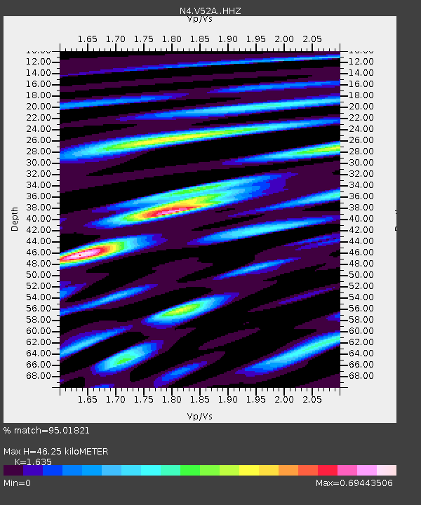
| Estimated Moho Depth: |
46.25 km |
| Estimated Crust Vp/Vs: |
1.63 |
| Assumed Crust Vp: |
6.35 km/s |
| Estimated Crust Vs: |
3.884 km/s |
| Estimated Crust Poisson's Ratio: |
0.20 |
|
| Radial Match: |
95.01821 % |
| Radial Bump: |
400 |
| Transverse Match: |
80.158714 % |
| Transverse Bump: |
400 |
| SOD ConfigId: |
13570011 |
| Insert Time: |
2019-04-28 03:12:25.494 +0000 |
| GWidth: |
2.5 |
| Max Bumps: |
400 |
| Tol: |
0.001 |
|

Signal To Noise
| Channel | StoN | STA | LTA |
| N4:V52A: :HHZ:20170602T22:35:28.40999Z | 23.583147 | 1.5536176E-6 | 6.58783E-8 |
| N4:V52A: :HHN:20170602T22:35:28.40999Z | 9.43947 | 5.070153E-7 | 5.3712256E-8 |
| N4:V52A: :HHE:20170602T22:35:28.40999Z | 6.65563 | 4.6235934E-7 | 6.94689E-8 |
| Arrivals |
| Ps | 4.8 SECOND |
| PpPs | 18 SECOND |
| PsPs/PpSs | 23 SECOND |


