You are here: Home > Network List > N4 - Central and EAstern US Network Stations List
> Station V58A WIndy Hill, Pittsboro, NC, USA > Earthquake Result Viewer
V58A WIndy Hill, Pittsboro, NC, USA - Earthquake Result Viewer
| Earthquake location: |
Near Islands, Aleutian Islands |
| Earthquake latitude/longitude: |
54.0/170.9 |
| Earthquake time(UTC): |
2017/06/02 (153) 22:24:47 GMT |
| Earthquake Depth: |
8.2 km |
| Earthquake Magnitude: |
6.8 Mww |
| Earthquake Catalog/Contributor: |
NEIC PDE/us |
|
| Network: |
N4 Central and EAstern US Network |
| Station: |
V58A WIndy Hill, Pittsboro, NC, USA |
| Lat/Lon: |
35.79 N/79.11 W |
| Elevation: |
127 m |
|
| Distance: |
72.2 deg |
| Az: |
53.384 deg |
| Baz: |
324.376 deg |
| Ray Param: |
0.053847298 |
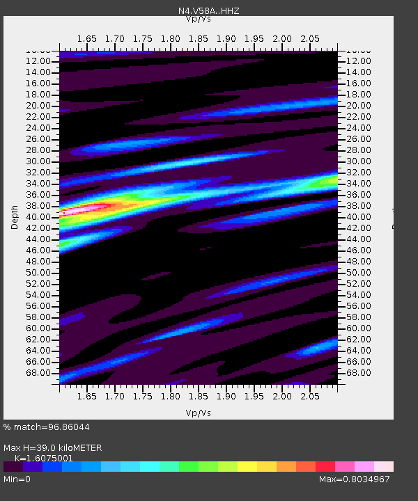
| Estimated Moho Depth: |
39.0 km |
| Estimated Crust Vp/Vs: |
1.61 |
| Assumed Crust Vp: |
6.565 km/s |
| Estimated Crust Vs: |
4.084 km/s |
| Estimated Crust Poisson's Ratio: |
0.18 |
|
| Radial Match: |
96.86044 % |
| Radial Bump: |
310 |
| Transverse Match: |
91.85205 % |
| Transverse Bump: |
400 |
| SOD ConfigId: |
13570011 |
| Insert Time: |
2019-04-28 03:12:28.757 +0000 |
| GWidth: |
2.5 |
| Max Bumps: |
400 |
| Tol: |
0.001 |
|

Signal To Noise
| Channel | StoN | STA | LTA |
| N4:V58A: :HHZ:20170602T22:35:41.729998Z | 31.81342 | 1.7985323E-6 | 5.653376E-8 |
| N4:V58A: :HHN:20170602T22:35:41.729998Z | 14.938334 | 6.798423E-7 | 4.550991E-8 |
| N4:V58A: :HHE:20170602T22:35:41.729998Z | 9.271208 | 4.9936045E-7 | 5.3861424E-8 |
| Arrivals |
| Ps | 3.8 SECOND |
| PpPs | 15 SECOND |
| PsPs/PpSs | 19 SECOND |


