You are here: Home > Network List > NM - Cooperative New Madrid Seismic Network Stations List
> Station UTMT Martin, TN > Earthquake Result Viewer
UTMT Martin, TN - Earthquake Result Viewer
| Earthquake location: |
Near Islands, Aleutian Islands |
| Earthquake latitude/longitude: |
54.0/170.9 |
| Earthquake time(UTC): |
2017/06/02 (153) 22:24:47 GMT |
| Earthquake Depth: |
8.2 km |
| Earthquake Magnitude: |
6.8 Mww |
| Earthquake Catalog/Contributor: |
NEIC PDE/us |
|
| Network: |
NM Cooperative New Madrid Seismic Network |
| Station: |
UTMT Martin, TN |
| Lat/Lon: |
36.35 N/88.86 W |
| Elevation: |
110 m |
|
| Distance: |
66.9 deg |
| Az: |
59.72 deg |
| Baz: |
320.871 deg |
| Ray Param: |
0.057296064 |
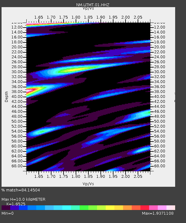
| Estimated Moho Depth: |
10.0 km |
| Estimated Crust Vp/Vs: |
1.65 |
| Assumed Crust Vp: |
6.444 km/s |
| Estimated Crust Vs: |
3.899 km/s |
| Estimated Crust Poisson's Ratio: |
0.21 |
|
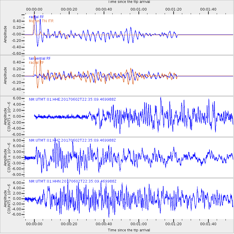
| Radial Match: |
84.14504 % |
| Radial Bump: |
400 |
| Transverse Match: |
80.87741 % |
| Transverse Bump: |
400 |
| SOD ConfigId: |
13570011 |
| Insert Time: |
2019-04-28 03:12:54.665 +0000 |
| GWidth: |
2.5 |
| Max Bumps: |
400 |
| Tol: |
0.001 |
|
Signal To Noise
| Channel | StoN | STA | LTA |
| NM:UTMT:01:HHZ:20170602T22:35:09.469988Z | 5.943898 | 2.9284288E-6 | 4.9267817E-7 |
| NM:UTMT:01:HHN:20170602T22:35:09.469988Z | 2.2263007 | 8.5963467E-7 | 3.8612694E-7 |
| NM:UTMT:01:HHE:20170602T22:35:09.469988Z | 2.3451502 | 6.820917E-7 | 2.9085203E-7 |
| Arrivals |
| Ps | 1.1 SECOND |
| PpPs | 3.9 SECOND |
| PsPs/PpSs | 5.0 SECOND |


