You are here: Home > Network List > NN - Western Great Basin/Eastern Sierra Nevada Stations List
> Station EMB Emerald Bay, California w84 > Earthquake Result Viewer
EMB Emerald Bay, California w84 - Earthquake Result Viewer
| Earthquake location: |
Near Islands, Aleutian Islands |
| Earthquake latitude/longitude: |
54.0/170.9 |
| Earthquake time(UTC): |
2017/06/02 (153) 22:24:47 GMT |
| Earthquake Depth: |
8.2 km |
| Earthquake Magnitude: |
6.8 Mww |
| Earthquake Catalog/Contributor: |
NEIC PDE/us |
|
| Network: |
NN Western Great Basin/Eastern Sierra Nevada |
| Station: |
EMB Emerald Bay, California w84 |
| Lat/Lon: |
38.97 N/120.10 W |
| Elevation: |
2134 m |
|
| Distance: |
47.9 deg |
| Az: |
78.815 deg |
| Baz: |
312.057 deg |
| Ray Param: |
0.06971527 |
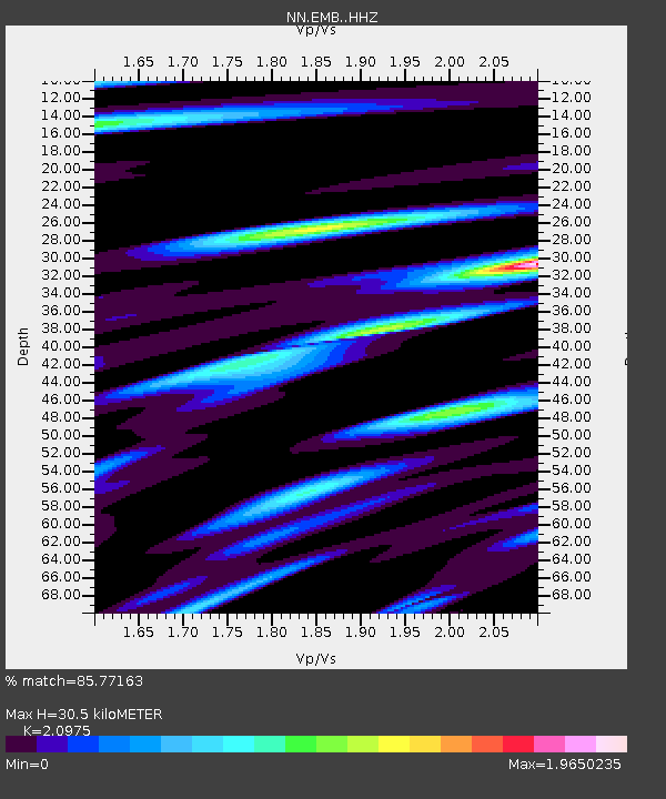
| Estimated Moho Depth: |
30.5 km |
| Estimated Crust Vp/Vs: |
2.10 |
| Assumed Crust Vp: |
6.597 km/s |
| Estimated Crust Vs: |
3.145 km/s |
| Estimated Crust Poisson's Ratio: |
0.35 |
|
| Radial Match: |
85.77163 % |
| Radial Bump: |
400 |
| Transverse Match: |
83.04601 % |
| Transverse Bump: |
400 |
| SOD ConfigId: |
13570011 |
| Insert Time: |
2019-04-28 03:12:58.858 +0000 |
| GWidth: |
2.5 |
| Max Bumps: |
400 |
| Tol: |
0.001 |
|

Signal To Noise
| Channel | StoN | STA | LTA |
| NN:EMB: :HHZ:20170602T22:32:55.348009Z | 26.803617 | 2.4790947E-6 | 9.249105E-8 |
| NN:EMB: :HHN:20170602T22:32:55.348009Z | 10.236441 | 1.0776023E-6 | 1.0527119E-7 |
| NN:EMB: :HHE:20170602T22:32:55.348009Z | 11.6243 | 1.0043603E-6 | 8.64018E-8 |
| Arrivals |
| Ps | 5.4 SECOND |
| PpPs | 14 SECOND |
| PsPs/PpSs | 19 SECOND |


