You are here: Home > Network List > TA - USArray Transportable Network (new EarthScope stations) Stations List
> Station W31A Holland Ranch, Erick, OK, USA > Earthquake Result Viewer
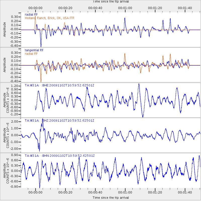
W31A Holland Ranch, Erick, OK, USA - Earthquake Result Viewer
*The percent match for this event was below the threshold and hence no stack was calculated.
| Earthquake location: |
South Of Tonga Islands |
| Earthquake latitude/longitude: |
-24.1/-175.2 |
| Earthquake time(UTC): |
2009/11/02 (306) 10:47:13 GMT |
| Earthquake Depth: |
9.0 km |
| Earthquake Magnitude: |
6.1 MB, 6.1 MS, 6.2 MW, 6.1 MW |
| Earthquake Catalog/Contributor: |
WHDF/NEIC |
|
| Network: |
TA USArray Transportable Network (new EarthScope stations) |
| Station: |
W31A Holland Ranch, Erick, OK, USA |
| Lat/Lon: |
35.19 N/99.94 W |
| Elevation: |
644 m |
|
| Distance: |
92.4 deg |
| Az: |
52.442 deg |
| Baz: |
242.166 deg |
| Ray Param: |
$rayparam |
*The percent match for this event was below the threshold and hence was not used in the summary stack. |
|
| Radial Match: |
57.959435 % |
| Radial Bump: |
400 |
| Transverse Match: |
58.666958 % |
| Transverse Bump: |
400 |
| SOD ConfigId: |
2622 |
| Insert Time: |
2010-03-06 00:20:15.972 +0000 |
| GWidth: |
2.5 |
| Max Bumps: |
400 |
| Tol: |
0.001 |
|
Signal To Noise
| Channel | StoN | STA | LTA |
| TA:W31A: :BHZ:20091102T10:59:52.62501Z | 2.2376835 | 1.2047692E-6 | 5.384002E-7 |
| TA:W31A: :BHN:20091102T10:59:52.62501Z | 0.8492488 | 4.2495947E-7 | 5.003945E-7 |
| TA:W31A: :BHE:20091102T10:59:52.62501Z | 1.3294417 | 5.571562E-7 | 4.190904E-7 |
| Arrivals |
| Ps | |
| PpPs | |
| PsPs/PpSs | |


