You are here: Home > Network List > NN - Western Great Basin/Eastern Sierra Nevada Stations List
> Station MOHS Mojave High School, LLNL/ANSS BB+SM w84gm > Earthquake Result Viewer
MOHS Mojave High School, LLNL/ANSS BB+SM w84gm - Earthquake Result Viewer
| Earthquake location: |
Near Islands, Aleutian Islands |
| Earthquake latitude/longitude: |
54.0/170.9 |
| Earthquake time(UTC): |
2017/06/02 (153) 22:24:47 GMT |
| Earthquake Depth: |
8.2 km |
| Earthquake Magnitude: |
6.8 Mww |
| Earthquake Catalog/Contributor: |
NEIC PDE/us |
|
| Network: |
NN Western Great Basin/Eastern Sierra Nevada |
| Station: |
MOHS Mojave High School, LLNL/ANSS BB+SM w84gm |
| Lat/Lon: |
36.25 N/115.14 W |
| Elevation: |
623 m |
|
| Distance: |
52.6 deg |
| Az: |
77.871 deg |
| Baz: |
314.472 deg |
| Ray Param: |
0.06665364 |
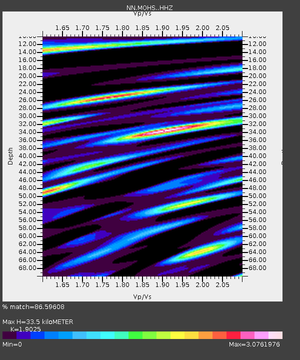
| Estimated Moho Depth: |
33.5 km |
| Estimated Crust Vp/Vs: |
1.90 |
| Assumed Crust Vp: |
6.276 km/s |
| Estimated Crust Vs: |
3.299 km/s |
| Estimated Crust Poisson's Ratio: |
0.31 |
|
| Radial Match: |
86.59608 % |
| Radial Bump: |
400 |
| Transverse Match: |
77.87844 % |
| Transverse Bump: |
400 |
| SOD ConfigId: |
13570011 |
| Insert Time: |
2019-04-28 03:13:02.887 +0000 |
| GWidth: |
2.5 |
| Max Bumps: |
400 |
| Tol: |
0.001 |
|

Signal To Noise
| Channel | StoN | STA | LTA |
| NN:MOHS: :HHZ:20170602T22:33:31.125017Z | 3.645149 | 3.3736148E-6 | 9.255081E-7 |
| NN:MOHS: :HHN:20170602T22:33:31.125017Z | 2.813931 | 1.9570252E-6 | 6.9547735E-7 |
| NN:MOHS: :HHE:20170602T22:33:31.125017Z | 2.0364041 | 1.5871415E-6 | 7.793843E-7 |
| Arrivals |
| Ps | 5.1 SECOND |
| PpPs | 15 SECOND |
| PsPs/PpSs | 20 SECOND |


