You are here: Home > Network List > WI - West Indies IPGP Network Stations List
> Station TDBA Terre de Bas, Les Saintes > Earthquake Result Viewer
TDBA Terre de Bas, Les Saintes - Earthquake Result Viewer
| Earthquake location: |
Near Coast Of Chiapas, Mexico |
| Earthquake latitude/longitude: |
15.9/-93.4 |
| Earthquake time(UTC): |
2015/12/17 (351) 19:49:54 GMT |
| Earthquake Depth: |
97 km |
| Earthquake Magnitude: |
6.4 MWB, 6.6 MI |
| Earthquake Catalog/Contributor: |
NEIC PDE/NEIC COMCAT |
|
| Network: |
WI West Indies IPGP Network |
| Station: |
TDBA Terre de Bas, Les Saintes |
| Lat/Lon: |
15.85 N/61.64 W |
| Elevation: |
176 m |
|
| Distance: |
30.6 deg |
| Az: |
85.64 deg |
| Baz: |
274.493 deg |
| Ray Param: |
0.07914027 |
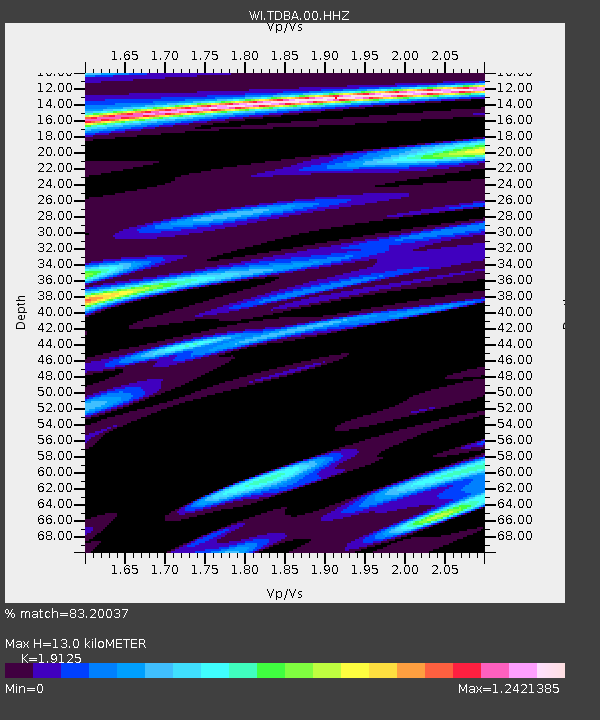
| Estimated Moho Depth: |
13.0 km |
| Estimated Crust Vp/Vs: |
1.91 |
| Assumed Crust Vp: |
5.88 km/s |
| Estimated Crust Vs: |
3.075 km/s |
| Estimated Crust Poisson's Ratio: |
0.31 |
|
| Radial Match: |
83.20037 % |
| Radial Bump: |
400 |
| Transverse Match: |
71.19197 % |
| Transverse Bump: |
400 |
| SOD ConfigId: |
1259291 |
| Insert Time: |
2015-12-31 20:23:51.261 +0000 |
| GWidth: |
2.5 |
| Max Bumps: |
400 |
| Tol: |
0.001 |
|

Signal To Noise
| Channel | StoN | STA | LTA |
| WI:TDBA:00:HHZ:20151217T19:55:29.159989Z | 11.135739 | 4.0035243E-6 | 3.5952027E-7 |
| WI:TDBA:00:HHN:20151217T19:55:29.159989Z | 1.9182982 | 1.3566535E-6 | 7.072172E-7 |
| WI:TDBA:00:HHE:20151217T19:55:29.159989Z | 4.9619875 | 3.072156E-6 | 6.191382E-7 |
| Arrivals |
| Ps | 2.1 SECOND |
| PpPs | 6.1 SECOND |
| PsPs/PpSs | 8.2 SECOND |


