You are here: Home > Network List > TA - USArray Transportable Network (new EarthScope stations) Stations List
> Station O16A Springville, UT, USA > Earthquake Result Viewer
O16A Springville, UT, USA - Earthquake Result Viewer
| Earthquake location: |
Kuril Islands |
| Earthquake latitude/longitude: |
46.0/151.5 |
| Earthquake time(UTC): |
2009/04/07 (097) 04:23:33 GMT |
| Earthquake Depth: |
31 km |
| Earthquake Magnitude: |
6.5 MB, 6.8 MS, 6.9 MW, 6.9 MW |
| Earthquake Catalog/Contributor: |
WHDF/NEIC |
|
| Network: |
TA USArray Transportable Network (new EarthScope stations) |
| Station: |
O16A Springville, UT, USA |
| Lat/Lon: |
40.21 N/111.50 W |
| Elevation: |
1789 m |
|
| Distance: |
66.6 deg |
| Az: |
55.92 deg |
| Baz: |
311.131 deg |
| Ray Param: |
0.057450365 |
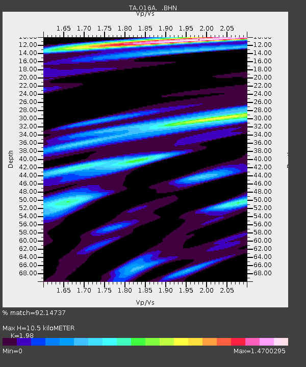
| Estimated Moho Depth: |
10.5 km |
| Estimated Crust Vp/Vs: |
1.98 |
| Assumed Crust Vp: |
6.155 km/s |
| Estimated Crust Vs: |
3.109 km/s |
| Estimated Crust Poisson's Ratio: |
0.33 |
|
| Radial Match: |
92.14737 % |
| Radial Bump: |
400 |
| Transverse Match: |
82.09178 % |
| Transverse Bump: |
400 |
| SOD ConfigId: |
2658 |
| Insert Time: |
2010-03-06 00:20:29.157 +0000 |
| GWidth: |
2.5 |
| Max Bumps: |
400 |
| Tol: |
0.001 |
|
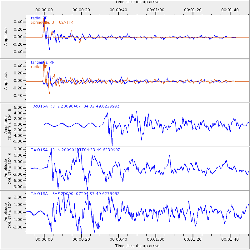
Signal To Noise
| Channel | StoN | STA | LTA |
| TA:O16A: :BHN:20090407T04:33:49.623999Z | 26.20821 | 4.118653E-6 | 1.5715125E-7 |
| TA:O16A: :BHE:20090407T04:33:49.623999Z | 9.552773 | 9.904659E-7 | 1.0368359E-7 |
| TA:O16A: :BHZ:20090407T04:33:49.623999Z | 4.5221677 | 2.0381008E-6 | 4.5069112E-7 |
| Arrivals |
| Ps | 1.7 SECOND |
| PpPs | 4.9 SECOND |
| PsPs/PpSs | 6.6 SECOND |


