You are here: Home > Network List > WY - Yellowstone Wyoming Seismic Network Stations List
> Station YHR Hawk's Rest, WY, USA > Earthquake Result Viewer
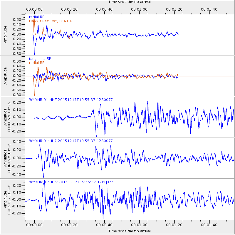
YHR Hawk's Rest, WY, USA - Earthquake Result Viewer
*The percent match for this event was below the threshold and hence no stack was calculated.
| Earthquake location: |
Near Coast Of Chiapas, Mexico |
| Earthquake latitude/longitude: |
15.9/-93.4 |
| Earthquake time(UTC): |
2015/12/17 (351) 19:49:54 GMT |
| Earthquake Depth: |
97 km |
| Earthquake Magnitude: |
6.4 MWB, 6.6 MI |
| Earthquake Catalog/Contributor: |
NEIC PDE/NEIC COMCAT |
|
| Network: |
WY Yellowstone Wyoming Seismic Network |
| Station: |
YHR Hawk's Rest, WY, USA |
| Lat/Lon: |
44.11 N/110.08 W |
| Elevation: |
2976 m |
|
| Distance: |
31.5 deg |
| Az: |
336.711 deg |
| Baz: |
148.121 deg |
| Ray Param: |
$rayparam |
*The percent match for this event was below the threshold and hence was not used in the summary stack. |
|
| Radial Match: |
86.02626 % |
| Radial Bump: |
400 |
| Transverse Match: |
82.24693 % |
| Transverse Bump: |
400 |
| SOD ConfigId: |
1259291 |
| Insert Time: |
2015-12-31 20:24:36.091 +0000 |
| GWidth: |
2.5 |
| Max Bumps: |
400 |
| Tol: |
0.001 |
|
Signal To Noise
| Channel | StoN | STA | LTA |
| WY:YHR:01:HHZ:20151217T19:55:37.128007Z | 20.015947 | 1.4081944E-7 | 7.0353625E-9 |
| WY:YHR:01:HHN:20151217T19:55:37.128007Z | 7.1909056 | 7.2997004E-8 | 1.0151295E-8 |
| WY:YHR:01:HHE:20151217T19:55:37.128007Z | 3.2240667 | 4.5830987E-8 | 1.42152725E-8 |
| Arrivals |
| Ps | |
| PpPs | |
| PsPs/PpSs | |


