You are here: Home > Network List > TA - USArray Transportable Network (new EarthScope stations) Stations List
> Station O16A Springville, UT, USA > Earthquake Result Viewer
O16A Springville, UT, USA - Earthquake Result Viewer
| Earthquake location: |
Loyalty Islands |
| Earthquake latitude/longitude: |
-20.2/168.9 |
| Earthquake time(UTC): |
2008/04/09 (100) 11:13:17 GMT |
| Earthquake Depth: |
13 km |
| Earthquake Magnitude: |
5.6 MB, 6.3 MS, 6.4 MW, 6.3 MW |
| Earthquake Catalog/Contributor: |
WHDF/NEIC |
|
| Network: |
TA USArray Transportable Network (new EarthScope stations) |
| Station: |
O16A Springville, UT, USA |
| Lat/Lon: |
40.21 N/111.50 W |
| Elevation: |
1789 m |
|
| Distance: |
95.2 deg |
| Az: |
49.157 deg |
| Baz: |
248.113 deg |
| Ray Param: |
0.04083757 |
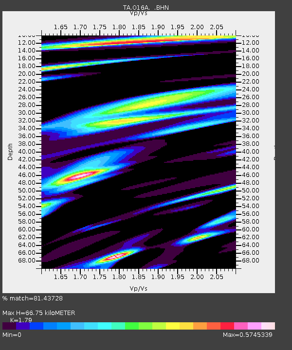
| Estimated Moho Depth: |
66.75 km |
| Estimated Crust Vp/Vs: |
1.79 |
| Assumed Crust Vp: |
6.155 km/s |
| Estimated Crust Vs: |
3.438 km/s |
| Estimated Crust Poisson's Ratio: |
0.27 |
|
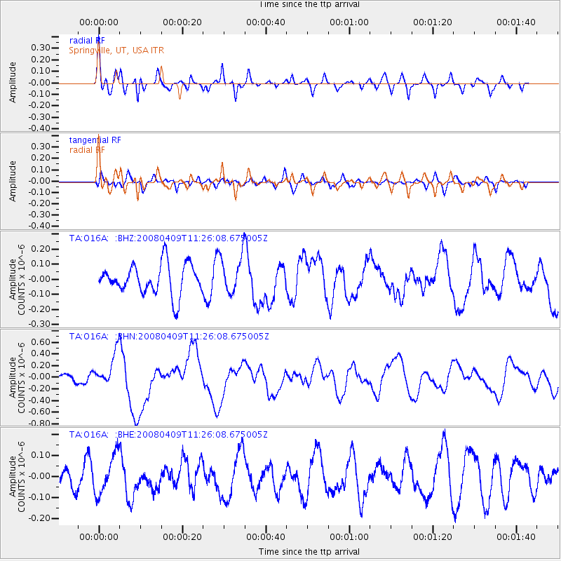
| Radial Match: |
81.43728 % |
| Radial Bump: |
400 |
| Transverse Match: |
61.967476 % |
| Transverse Bump: |
400 |
| SOD ConfigId: |
2504 |
| Insert Time: |
2010-03-06 00:20:32.230 +0000 |
| GWidth: |
2.5 |
| Max Bumps: |
400 |
| Tol: |
0.001 |
|
Signal To Noise
| Channel | StoN | STA | LTA |
| TA:O16A: :BHN:20080409T11:26:08.675005Z | 3.4616218 | 3.0458065E-7 | 8.798785E-8 |
| TA:O16A: :BHE:20080409T11:26:08.675005Z | 2.3823855 | 9.596742E-8 | 4.028207E-8 |
| TA:O16A: :BHZ:20080409T11:26:08.675005Z | 1.2600416 | 1.259939E-7 | 9.999186E-8 |
| Arrivals |
| Ps | 8.7 SECOND |
| PpPs | 30 SECOND |
| PsPs/PpSs | 38 SECOND |


