You are here: Home > Network List > PE - Penn State Network Stations List
> Station PAKS Keystone State Park, Derry Township, PA > Earthquake Result Viewer
PAKS Keystone State Park, Derry Township, PA - Earthquake Result Viewer
| Earthquake location: |
Near Islands, Aleutian Islands |
| Earthquake latitude/longitude: |
54.0/170.9 |
| Earthquake time(UTC): |
2017/06/02 (153) 22:24:47 GMT |
| Earthquake Depth: |
8.2 km |
| Earthquake Magnitude: |
6.8 Mww |
| Earthquake Catalog/Contributor: |
NEIC PDE/us |
|
| Network: |
PE Penn State Network |
| Station: |
PAKS Keystone State Park, Derry Township, PA |
| Lat/Lon: |
40.38 N/79.38 W |
| Elevation: |
336 m |
|
| Distance: |
68.3 deg |
| Az: |
50.696 deg |
| Baz: |
323.304 deg |
| Ray Param: |
0.056368 |
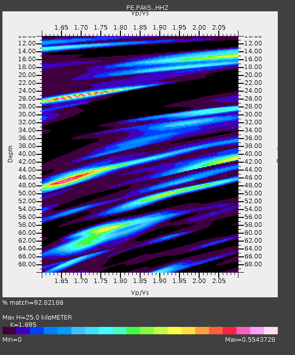
| Estimated Moho Depth: |
25.0 km |
| Estimated Crust Vp/Vs: |
1.70 |
| Assumed Crust Vp: |
6.121 km/s |
| Estimated Crust Vs: |
3.611 km/s |
| Estimated Crust Poisson's Ratio: |
0.23 |
|
| Radial Match: |
92.82186 % |
| Radial Bump: |
400 |
| Transverse Match: |
75.406296 % |
| Transverse Bump: |
400 |
| SOD ConfigId: |
13570011 |
| Insert Time: |
2019-04-28 03:14:25.460 +0000 |
| GWidth: |
2.5 |
| Max Bumps: |
400 |
| Tol: |
0.001 |
|

Signal To Noise
| Channel | StoN | STA | LTA |
| PE:PAKS: :HHZ:20170602T22:35:18.414995Z | 15.899074 | 2.0644525E-6 | 1.2984735E-7 |
| PE:PAKS: :HHN:20170602T22:35:18.414995Z | 4.5703025 | 6.757726E-7 | 1.4786167E-7 |
| PE:PAKS: :HHE:20170602T22:35:18.414995Z | 2.5621297 | 4.5407208E-7 | 1.7722445E-7 |
| Arrivals |
| Ps | 2.9 SECOND |
| PpPs | 11 SECOND |
| PsPs/PpSs | 14 SECOND |


