You are here: Home > Network List > PE - Penn State Network Stations List
> Station PSWB Penn State Wilkes-Barre > Earthquake Result Viewer
PSWB Penn State Wilkes-Barre - Earthquake Result Viewer
| Earthquake location: |
Near Islands, Aleutian Islands |
| Earthquake latitude/longitude: |
54.0/170.9 |
| Earthquake time(UTC): |
2017/06/02 (153) 22:24:47 GMT |
| Earthquake Depth: |
8.2 km |
| Earthquake Magnitude: |
6.8 Mww |
| Earthquake Catalog/Contributor: |
NEIC PDE/us |
|
| Network: |
PE Penn State Network |
| Station: |
PSWB Penn State Wilkes-Barre |
| Lat/Lon: |
41.31 N/76.02 W |
| Elevation: |
398 m |
|
| Distance: |
69.1 deg |
| Az: |
47.896 deg |
| Baz: |
324.48 deg |
| Ray Param: |
0.055874374 |
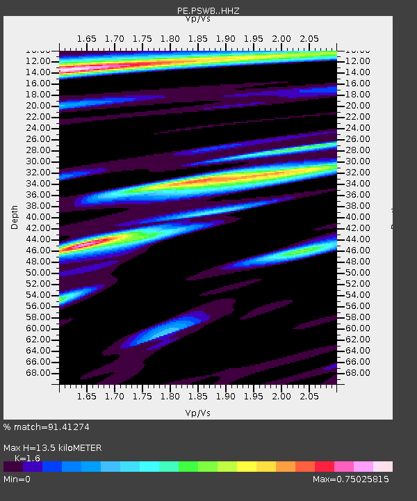
| Estimated Moho Depth: |
13.5 km |
| Estimated Crust Vp/Vs: |
1.60 |
| Assumed Crust Vp: |
6.121 km/s |
| Estimated Crust Vs: |
3.825 km/s |
| Estimated Crust Poisson's Ratio: |
0.18 |
|
| Radial Match: |
91.41274 % |
| Radial Bump: |
400 |
| Transverse Match: |
74.61021 % |
| Transverse Bump: |
400 |
| SOD ConfigId: |
13570011 |
| Insert Time: |
2019-04-28 03:14:36.737 +0000 |
| GWidth: |
2.5 |
| Max Bumps: |
400 |
| Tol: |
0.001 |
|

Signal To Noise
| Channel | StoN | STA | LTA |
| PE:PSWB: :HHZ:20170602T22:35:23.070024Z | 13.103266 | 1.3794408E-6 | 1.0527458E-7 |
| PE:PSWB: :HHN:20170602T22:35:23.070024Z | 3.1501114 | 3.07521E-7 | 9.7622255E-8 |
| PE:PSWB: :HHE:20170602T22:35:23.070024Z | 3.2510238 | 3.8247055E-7 | 1.1764618E-7 |
| Arrivals |
| Ps | 1.4 SECOND |
| PpPs | 5.5 SECOND |
| PsPs/PpSs | 6.9 SECOND |


