You are here: Home > Network List > PL - Polish Seismological Network Stations List
> Station SUW PLSN/GEOFON Station Suwalki, Poland > Earthquake Result Viewer
SUW PLSN/GEOFON Station Suwalki, Poland - Earthquake Result Viewer
| Earthquake location: |
Near Islands, Aleutian Islands |
| Earthquake latitude/longitude: |
54.0/170.9 |
| Earthquake time(UTC): |
2017/06/02 (153) 22:24:47 GMT |
| Earthquake Depth: |
8.2 km |
| Earthquake Magnitude: |
6.8 Mww |
| Earthquake Catalog/Contributor: |
NEIC PDE/us |
|
| Network: |
PL Polish Seismological Network |
| Station: |
SUW PLSN/GEOFON Station Suwalki, Poland |
| Lat/Lon: |
54.01 N/23.18 E |
| Elevation: |
152 m |
|
| Distance: |
69.1 deg |
| Az: |
340.281 deg |
| Baz: |
19.711 deg |
| Ray Param: |
0.055901226 |
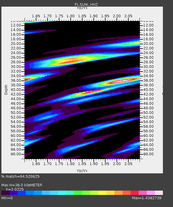
| Estimated Moho Depth: |
36.0 km |
| Estimated Crust Vp/Vs: |
2.02 |
| Assumed Crust Vp: |
6.53 km/s |
| Estimated Crust Vs: |
3.229 km/s |
| Estimated Crust Poisson's Ratio: |
0.34 |
|
| Radial Match: |
94.528625 % |
| Radial Bump: |
400 |
| Transverse Match: |
86.97432 % |
| Transverse Bump: |
400 |
| SOD ConfigId: |
13570011 |
| Insert Time: |
2019-04-28 03:14:41.767 +0000 |
| GWidth: |
2.5 |
| Max Bumps: |
400 |
| Tol: |
0.001 |
|

Signal To Noise
| Channel | StoN | STA | LTA |
| PL:SUW: :HHZ:20170602T22:35:22.854998Z | 13.402329 | 2.4923168E-6 | 1.8596147E-7 |
| PL:SUW: :HHN:20170602T22:35:22.854998Z | 3.8316622 | 1.8184342E-6 | 4.7458104E-7 |
| PL:SUW: :HHE:20170602T22:35:22.854998Z | 1.7342004 | 4.3782913E-7 | 2.5246743E-7 |
| Arrivals |
| Ps | 5.8 SECOND |
| PpPs | 16 SECOND |
| PsPs/PpSs | 22 SECOND |


