You are here: Home > Network List > PY - PFO Array Stations List
> Station BPH06 Pinon Flat Observatory, CA, USA > Earthquake Result Viewer
BPH06 Pinon Flat Observatory, CA, USA - Earthquake Result Viewer
| Earthquake location: |
Near Islands, Aleutian Islands |
| Earthquake latitude/longitude: |
54.0/170.9 |
| Earthquake time(UTC): |
2017/06/02 (153) 22:24:47 GMT |
| Earthquake Depth: |
8.2 km |
| Earthquake Magnitude: |
6.8 Mww |
| Earthquake Catalog/Contributor: |
NEIC PDE/us |
|
| Network: |
PY PFO Array |
| Station: |
BPH06 Pinon Flat Observatory, CA, USA |
| Lat/Lon: |
33.61 N/116.45 W |
| Elevation: |
1294 m |
|
| Distance: |
53.7 deg |
| Az: |
81.153 deg |
| Baz: |
315.691 deg |
| Ray Param: |
0.06591806 |
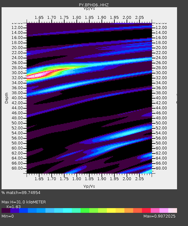
| Estimated Moho Depth: |
31.0 km |
| Estimated Crust Vp/Vs: |
1.63 |
| Assumed Crust Vp: |
6.264 km/s |
| Estimated Crust Vs: |
3.843 km/s |
| Estimated Crust Poisson's Ratio: |
0.20 |
|
| Radial Match: |
89.74954 % |
| Radial Bump: |
260 |
| Transverse Match: |
80.1903 % |
| Transverse Bump: |
400 |
| SOD ConfigId: |
13570011 |
| Insert Time: |
2019-04-28 03:15:04.426 +0000 |
| GWidth: |
2.5 |
| Max Bumps: |
400 |
| Tol: |
0.001 |
|

Signal To Noise
| Channel | StoN | STA | LTA |
| PY:BPH06: :HHZ:20170602T22:33:39.255022Z | 18.137594 | 1.9375825E-6 | 1.0682688E-7 |
| PY:BPH06: :HHN:20170602T22:33:39.255022Z | 6.6442204 | 8.0396615E-7 | 1.2100233E-7 |
| PY:BPH06: :HHE:20170602T22:33:39.255022Z | 5.791616 | 6.2786825E-7 | 1.0840985E-7 |
| Arrivals |
| Ps | 3.3 SECOND |
| PpPs | 12 SECOND |
| PsPs/PpSs | 16 SECOND |


